Baseline Evidence Paper
Other elements in this consultation

5.1Chichester district has a rich and varied natural environment stretching from the lowland marsh and creeks associated with Chichester Harbour and Pagham Harbour, across the coastal plain the South Downs National Park, and the Weald further north.
Designated sites
5.2The plan area has internationally designated habitats: Special Protection Areas (SPA), Special Areas of Conservation (SAC) and Ramsar sites, and nationally designated Sites of Special Scientific Interest (SSSI).
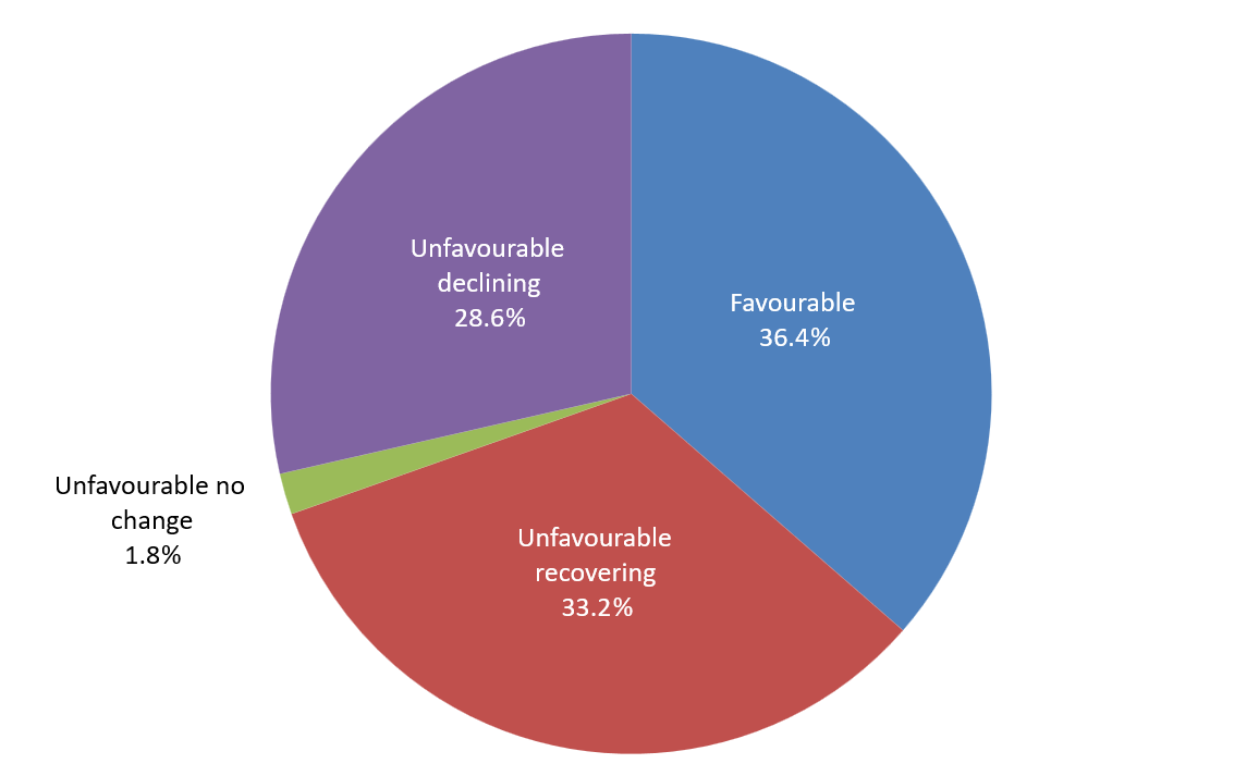
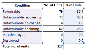
5.3In Chichester district, 36.4% of SSSI units are considered to be in a favourable condition. Of the SSSI units assessed as being in unfavourable condition, 72 are categorised as recovering against 62 declining, with 4 units showing no change. Parts of the Chichester Harbour SSSI were reclassified from unfavourable recovering to unfavourable no change in February 2019. Overall 66.6% of the SSSI area is in favourable or recovering condition. This is illustrated in Figure 5.
Internationally and nationally designated sites
5.4Chichester and Langstone Harbours and Pagham Harbour are designated as internationally important wildlife sites (Special Protection Areas), due to the presence of protected bird populations and the habitats that support them. There are particular pressures on these harbours from nitrate pollution, loss of intertidal habitat due to inappropriate coastal management, and recreational disturbances impacting upon the designated bird populations.
5.5The Bird Aware Solent Strategy was published in September 2024 and adopted by the council in December 2024. Monitoring of bird numbers and visitor numbers takes place and is published on the Bird Aware Solent website[8].
5.6The Arun Valley SPA, SAC and Ramsar site lies within the Sussex North Water Resource Zone which is partly served by supplies from groundwater abstraction at Pulborough. There are threats to this site arising from groundwater abstraction. The adopted plan contains policies relating to requirements for developments in this zone to be water neutral, however on 31 October 2025 Natural England issues a Withdrawal Statement confirming that its Water Neutrality Position Statement of September 2021 has been withdrawn, and meaning that development within the Sussex North Water Supply Zone is no longer required to demonstrate that it is water neutral[9].
5.7The Mens, Ebernoe Common and Singleton & Cocking Tunnels SACs are designated habitats for their Bechstein’s and barbastelle bat populations. Natural England has a draft protocol that applications for development must have regard to.
Chichester Harbour National Landscape
5.8Chichester Harbour National Landscape (formerly Area of Outstanding Natural Beauty) is a unique landscape of sheltered open water areas with contrasting narrow channels. The movement of the tide exposes bare mudflat and saltmarsh creating a wide, open and remote wilderness. The undeveloped character of the harbour is unique on the South Coast and its status as a Ramsar wetland, a Special Protection Area, a Special Area of Conservation and a Site of Special Scientific Interest reflects its importance to nature conservation.
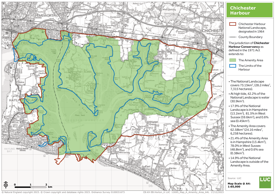
5.9Chichester Harbour Conservancy is responsible for the management of the Harbour, and has recently published the Chichester Harbour National Landscape Management Plan (2025-2030) Incorporating the Amenity Area & Harbour (2025)[10]. Figure 6 shows a map of the National Landscape.
5.10There are also various other local designations for biodiversity, heritage and landscape, such as National and Local Nature Reserves, as well as a number of Regionally Important Geological/Geomorphological sites.
5.11Relevant natural environment layers are available to view on the council’s baseline map. The relevant layers will need to be selected from the layers list and ‘toggled’ on.
