Local Plan 2045 Scoping Consultation
Other elements in this consultation
5. Spatial Strategy
5.1The draft NPPF ‘Policy S2: Producing a spatial strategy’ states that the spatial strategy sets clear expectations for the location of development and where land should be protected or enhanced for specific purposes. This includes:
- identifying settlements (existing or proposed) and their boundaries, including any allocations that would form part of the settlement;
- the location and boundary of town centres or other specific areas where a particular policy approach applies;
- land protected or proposed to be enhanced for specific purposes and which places limits on whether development proposals may be acceptable or where specific policies apply; and
- sites allocated for development to meet the identified need for housing and other uses and for local and strategic infrastructure.
5.2The spatial strategy is illustrated on a key diagram, with the detailed boundaries identified on a policies map.
Where are we now?
5.3The current local plan spatial strategy (Figure 1) seeks to disperse development across the plan area by:
- focusing the majority of planned sustainable growth at Chichester city and within the east-west corridor;
- reinforcing the role of Manhood Peninsula as a home to existing communities, tourism and agricultural enterprise; and
- supporting the villages and rural communities in the north of the plan area.
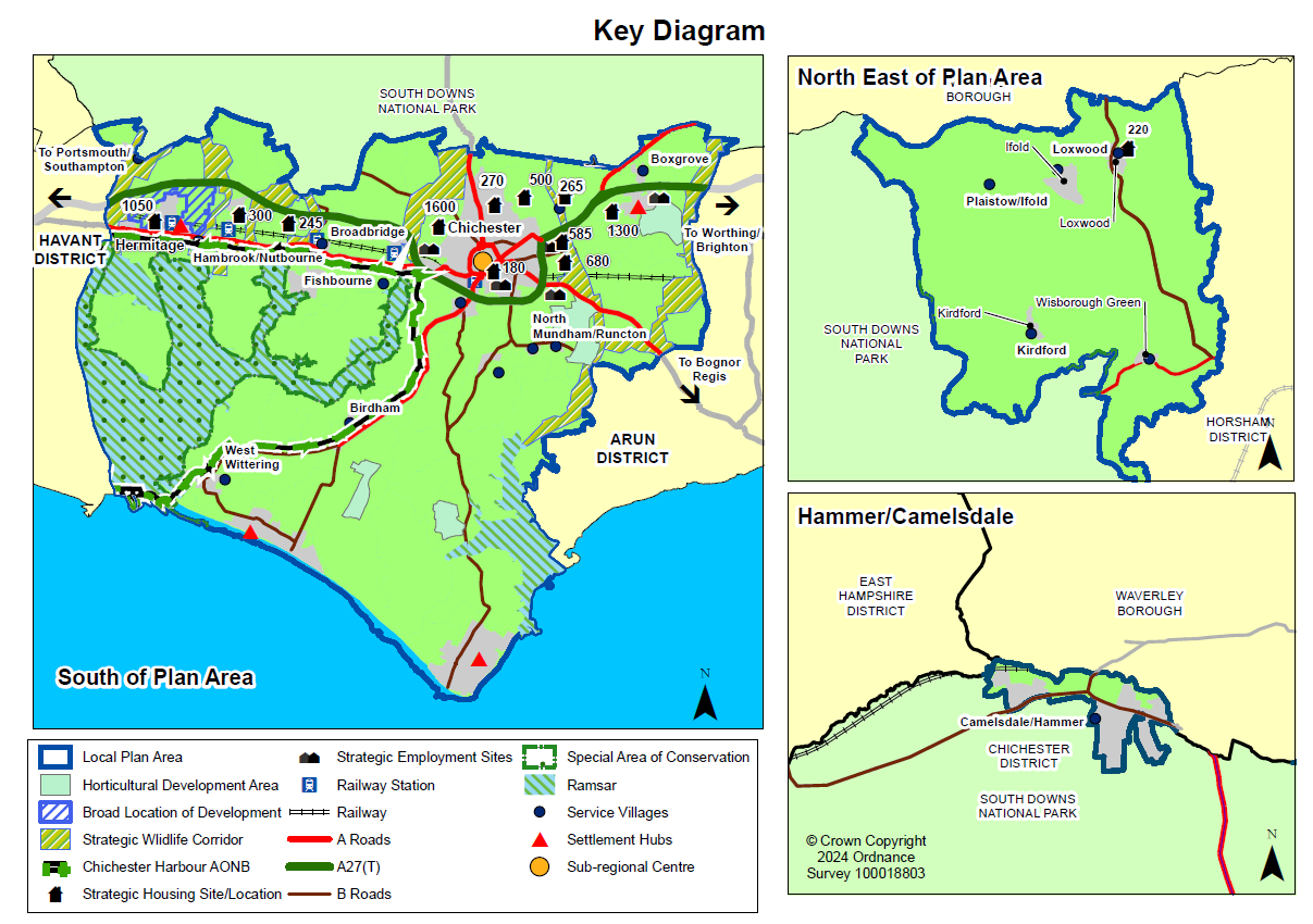
5.4The current local plan includes a settlement hierarchy which informed the spatial distribution of growth in the plan area, based on the role of each settlement (Table 1).
|
Settlement Type |
Communities |
|---|---|
|
Sub-Regional Centre |
Chichester city |
|
Settlement Hubs |
East Wittering / Bracklesham Selsey Southbourne Tangmere |
|
Service Villages |
Birdham, Bosham, Boxgrove, Camelsdale / Hammer, Fishbourne, Hambrook / Nutbourne, Hermitage, Hunston, Kirdford, Loxwood, North Mundham / Runcton, Plaistow / Ifold, Stockbridge, West Wittering, Westbourne, Westhampnett, Wisborough Green. |
|
Rest of the Plan area |
Small villages, hamlets, scattered development and countryside |
What are the challenges and opportunities?
Challenges
5.5The challenge will be to decide on a strategy for where development should go, which will be more difficult with the significant increase in the housing need figure.
5.6The spatial strategy will need to be informed by:
- the emerging sub-regional planning context being led by the Sussex and Brighton Strategic Authority;
- the overall vision, aims and measurable outcomes for the plan area and for the different sub-areas and settlements within it;
- the pattern of need and demand for housing and employment across the area;
- infrastructure capacity and constraints, in particular relating to wastewater treatment, roads and transport connectivity;
- environmental constraints – taking a sequential approach to avoiding flood risk areas, protecting environmental designations, landscape quality, the historic environment, best and most versatile agricultural land and maintaining individual settlement character;
- the availability of potential housing sites, their deliverability, market capacity and phasing; and
- public consultations, the strategic environmental assessment and other assessments of the plan as it developed.
5.7The challenge will be ensuring that there is up-to-date evidence to inform the spatial strategy, particularly around infrastructure capacity and environmental constraints. The evidence section sets out the proposed studies to ensure that decisions are informed by a proportionate evidence base.
Opportunities
5.8There is an opportunity to review the settlement hierarchy to account for any changes in the function of each settlement. There is also an opportunity to examine how settlements are defined in relation to the draft NPPF definition and use of the term settlement in the draft national decision-making policies.
5.9There is also an opportunity to review settlement boundaries to reflect the built-up area of each settlement and incorporate recent development.
What are the key priorities?
5.10To ensure the new local plan is supported by a clear and deliverable spatial strategy, the following key priorities have been identified.
Supporting climate-resilient patterns of growth
5.11Direct growth to locations that help reduce greenhouse gas emissions, avoid increased vulnerability to climate change and improve resilience to its effects. This includes considering flood risk, coastal change, access to services and opportunities to reduce the need to travel.
Promoting healthy and inclusive communities
5.12Shape spatial choices so that new development supports good health, helps prevent ill-health and encourages social interaction. Growth should be located where residents can access everyday services, community facilities, green space and opportunities for active lifestyles.
Locating development to support walking, cycling and public transport
5.13Prioritise locations where people can make more journeys by walking, cycling and public transport. The spatial strategy should support better connections between homes, jobs, schools, services and town and local centres, while reducing reliance on private car travel.
Strengthening town and local centres
5.14Support the role of Chichester city, town centres and local centres as accessible locations for services, employment, community facilities, leisure and cultural activity. The spatial strategy should help maintain their vitality and viability while supporting appropriate regeneration and mixed-use opportunities.
Conserving and enhancing environmental and heritage assets
5.15Ensure that growth responds positively to the natural, built and historic environment assets that make the plan area distinctive. Spatial choices should protect sensitive landscapes, designated habitats, heritage assets, settlement identity and the setting of the South Downs National Park and Chichester Harbour National Landscape.
Providing infrastructure to support growth
5.16Ensure that the location, scale and phasing of growth is informed by infrastructure capacity and delivery. This includes transport, water and wastewater, education, health, utilities, community facilities, open space and green and blue infrastructure.
Supporting economic growth and employment opportunities
5.17Locate growth where it can support existing and future employment opportunities, help retain and attract investment and provide good access between homes and jobs. The spatial strategy should consider the needs of key sectors, rural enterprise and the relationship between housing and employment growth.
Meeting housing needs across communities and life stages
5.18Plan for housing in locations that can help meet the needs of communities and people at different stages of life. This includes considering access to services, affordability, specialist accommodation needs, settlement roles and the relationship between new homes, infrastructure and employment.
