Southbourne Allocation Development Plan Document - Regulation 19 Consultation
Other elements in this consultation
Chapter 5: The Allocation and Framework Masterplan
Development Policies / Principles
5.1This section of the DPD focuses on the allocation itself. The key feature of this section is the identification of the land allocated for development as per policy A13 in the CLP, along with a framework masterplan for how the development should come forward.
Policy SA1 - East of Southbourne
The development of the site will need to accord with the requirements set out in policy A13 within the Chichester Local Plan 2021-39. The area covered by this DPD is set out in Figure 1, and the development of the site should accord with the framework masterplan set out in Figure 2 (unless otherwise agreed by the local planning authority).
The housing requirements set out in policy A13, including at least 800 dwellings, along with the A13 requirements in relation to specialist housing and gypsy and traveller pitches are to be provided in the development areas identified on the masterplan.
The following are also to be provided in the areas shown on the masterplan:
- A local centre, including local shops and a community centre;
- A one-form (expandable to two-form) entry primary school with provision for early years/childcare and special educational needs and disability (this supersedes the requirement for a two-form expandable to three-form entry requirement set out in policy A13);
- Open space, sports and recreation provision;
- Pedestrian and cycle routes and connections with the surrounding movement network; and
- Travelling Showpeople plots.
A landscape gap as per policy NE3 within the Chichester Local Plan 2021-39 has been defined on the masterplan. Any planning applications within that area will need to accord with policy NE3.
The masterplan identifies the areas being relied upon to ensure the provision of at least 800 homes, labelled as development areas on the masterplan. The masterplan also includes a number of potential development sites which may come forward at a later stage. Relevant applications will need to ensure that those sites can be delivered effectively, without ransom strips, and any applications for the development of those sites will need to be consistent with the relevant provisions of this DPD and policy A13 within the CLP.
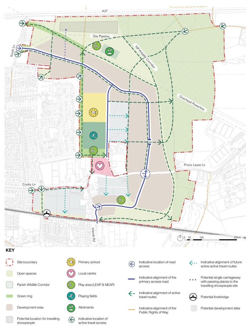
Figure 2 - Framework masterplan
5.2As per the reference in policy A13 to this DPD also setting out guidance for the delivery of the development, the following section runs through some of the key issues which underpin the allocation and the framework masterplan. The following section focuses on the objectives set out above and this section is structured accordingly.
Integrated and well serviced community
5.3The importance of social and community infrastructure is something which has been emphasised in the public consultation which has taken place and also in the SMNP.
Local centre
5.4The new local centre is a key part of the masterplan, especially given the dispersed location of existing facilities and services within the settlement. Therefore, a key issue for this DPD is to consolidate the new facilities and services in order to create a strong heart to the development.
5.5The local centre needs to be in as accessible a location as possible for the widest number of residents. Active travel accessibility must be maximised, with a direct connection to the Green Ring and the existing Public Right of Way running north from Priors Leaze Lane. Vehicular access, car parking and servicing will be provided from the northern access point (i.e. off South Lane).
5.6Crucially, the local centre needs to form part of a wider cluster of community focused uses including children’s play space, sports fields and the new primary school. This is vital for ensuring that the new development and this part of Southbourne generally has a vibrant heart.
5.7The local centre itself needs to comprise a coherent and consolidated cluster of community focused uses, including the community centre, local retail, residential units and workspaces (if possible) set around a central space that provides opportunities for community interaction, gathering and events. The masterplanning work undertaken on behalf of the council suggests that this area needs to be at least 0.50 ha.
5.8The design and layout of the local centre need to provide a welcoming civic focal point, reflective of the considerations set out above, with scale, massing, and materials that reinterpret the local vernacular in a positive and contemporary way.
Community centre
5.9A key part of the local centre will be the provision of a community centre. The Infrastructure Delivery Plan (IDP) requires this to be of sufficient size to accommodate a variety of recreational and social activities – a minimum of 18m x 10m, capacity of around 150 – 200 seated, with small meeting room, kitchen, storage and toilet facilities commensurate with size, with provision for disabled users and car parking. Overall, a net minimum of 666 sqm should be provided. It is specified in the IDP that the community centre should be able to accommodate a badminton court. The community centre will also need to incorporate changing facilities in order to complement the sports pitches located immediately to the north.
5.10The design and positioning of the community centre needs to ensure that it is well related to the sports and recreation facilities to the north. It is likely that the building will need to be designed and positioned so that it is orientated towards and forms an active frontage with that open space.
Parish Council
5.11Southbourne Parish Council are seeking to provide for new facilities as part of this project in order to support the work they do in serving the local community. This is centred around office and meeting space, along with ancillary spaces for things like storage. There is the potential to integrate these requirements into the community centre. Alternatively, this objective could be achieved via a new building designed to meet the specific needs of the parish council. However the provision is made, this premises will be a key feature of the new local centre.
Education
5.12Southbourne is well catered for in terms of existing education provision, as it contains an infant school, junior school and also Bourne Community College (a secondary school). However, additional provision will be needed as part of the new development. The IDP update sets out the requirements, with the new primary school being the key feature.
5.13The new primary school provides a key opportunity to give the development a focal point and to stimulate community cohesion. The school needs to be well related to the rest of the development and should be located in the heart of the layout, but not in a position that disrupts the proper functioning of the highway network.
5.14The primary school should be designed to make a positive contribution to the surrounding area and create an attractive frontage and welcoming entrance. Where edges of the school plot are located adjacent to public realm, the Green Ring or a street, these boundaries must be carefully designed to incorporate landscape/hedges and minimise the visual impact of high fences.
5.15Consideration needs to be given to how the school fits with the phasing of the development. It is likely to be most appropriate for the school to be delivered after approximately 500 residential units have been completed.
Housing for all
Market Housing
5.16Policy SB3 in the SMNP places special emphasis on the need for the provision of 1 or 2 bed dwellings suitable for younger households. Smaller accommodation is also needed in order to provide opportunities for downsizers, again, as referred to in the SMNP.
Affordable Housing
5.17The Local Housing Authority is currently in the process of updating the housing register. Future planning applications will need to be underpinned by discussions with the Local Housing Authority regarding the latest need position and in terms of what forms of accommodation and tenure are most suitable in order to meet the needs of the local community.
Specialist Housing
5.18Policy A13 within the CLP sets out some specific specialist housing requirements. This encompasses accommodation for older persons, self/custom build plots and pitches and plots for gypsies, travellers and travelling showpeople. The specific policies within the CLP regarding these housing and accommodation typologies provide detailed policy requirements, along with stipulations and guidance aimed at ensuring the most effective approach to making the necessary provision.
5.19With respect to older persons housing, it is likely that various different forms of accommodation will be required, including some levels of care or support. In general terms, particular regard should be given to ensuring that this is provided in close proximity to the local centre in order to ensure that the occupants can gain easy access to local facilities and services. This will also maximise the opportunities for an engaging outlook. However, for some forms of older persons accommodation a more secluded location may be more appropriate.
5.20For self/custom build housing, a mix of plot sizes should be provided to accommodate different sized dwellings. The plots should include the necessary service connections up to the boundary including road access and utility services. The plots should generally be grouped together to create distinct communities. The plots should be provided in a manner which will ensure that they are practical to build out i.e. so that there will not be a conflict with the construction activities being undertaken on the mainstream market housing built out by the main housebuilding company(s).
5.21In terms of gypsy and traveller and travelling showpeople provision, specific guidance in this regard is set out in the Local Plan, paragraphs 5.68 and 5.81. In the case of the gypsy and traveller pitches, these should be pepper-potted around in small groupings of 2 – 4 pitches. If a larger cluster of pitches is to be provided, then this is likely to require management arrangements to be put in place.
5.22For travelling showpeople provision, a potential location for these plots has been shown on the framework masterplan. These plots should be configured in such a way as to ensure that the storage areas are closest to A27 boundary in order to minimise the noise impacts on the living accommodation. There is potentially some flexibility in terms of the size of this area, as this depends upon the type of equipment which will be stored on the site, and hence a specific assessment of this form of provision should be prepared and submitted with the relevant outline application or reserved matters submission (including details of any potential off-site solutions for the provision in question). The approach to the provision of this form of accommodation should also be informed by the latest need position for this form of accommodation at the time relevant applications are considered.
Transport and Sustainable Travel
Travel in and around Southbourne
5.23It is clear from the transport evidence which has been produced, both by the council and site promoters, and from consultation with the Local Highway Authority, the parish council and through the public consultation, that there are some well-established transport issues which have a significant impact upon the functioning of Southbourne in transport terms and the quality of life of local residents. Primarily, these relate to the railway line, where the level crossing on Stein Road causes a lot of congestion within the village, particularly at peak times. This congestion also encourages drivers to seek alternative routes, which places additional pressure on the local road network.
5.24These issues have all been considered in detail throughout the process of producing this DPD. A key means of tackling this is to minimise the need for travel and maximise the use of sustainable modes of travel as an alternative to the private car. This is fundamental to the transport policies within the CLP and is a key goal of the high-level masterplan for this allocation.
5.25The masterplan sets out key active travel routes in order to ensure a high degree of connectivity and permeability in relation to both the allocation area and its surroundings. All relevant applications must demonstrate that they will either deliver or facilitate these routes/connections.
5.26Relevant applications must take the opportunity to improve the comfort and safety of those walking and cycling on Priors Leaze Lane, Inlands Road and Cooks Lane. To achieve this, traffic on these routes should be reduced by redirecting / encouraging traffic priority onto the new main routes through the new development. Thereby, creating the opportunity to improve the active travel environment on Priors Leaze Lane, Inlands Road, Cooks Lane and in so doing improve active travel access to the local centre, train station and other facilities and services within Southbourne.
Travel within the site
5.27The movement network within the site needs to be designed in order to facilitate a high degree of permeability in order to maximise walking and cycling. The Green Ring also provides a route through the development, linking in with a continuous route in and around the whole village. Streets and public spaces should follow the principles of the DfT Manual for Streets (latest version) and LTN1/ 20.
5.28Multiple pedestrian access points are to be provided along the western edge of the allocation. In the south-western part of the masterplan it will be important to provide a new pedestrian and cycle route adjacent to Cooks Lane, but preserving the hedge along the edge of the lane. There should also be a clearly defined route through the site linking in with a pedestrian/cycle bridge over the railway line.
5.29The masterplan is predicated upon transport work which demonstrates that the vehicular traffic needs to be split between two different access points in order to mitigate the impact of the additional traffic on the local road network. The development will be accessed via South Lane in the north and off Inlands Road and Priors Leaze Lane in the south. While not linked by a continuous vehicle route through the site, a potential bus route (utilising a bus gate or similar feature) through the two parts of the site should be facilitated and continuous active travel routes should be provided.
5.30The new junctions on Priors Leaze Lane and Inlands Road need to be designed to direct traffic into the southern parcel of the new development. This will ensure that through traffic uses the new road running through the southern development parcel, which will be wider and safer than Priors Leaze Lane.
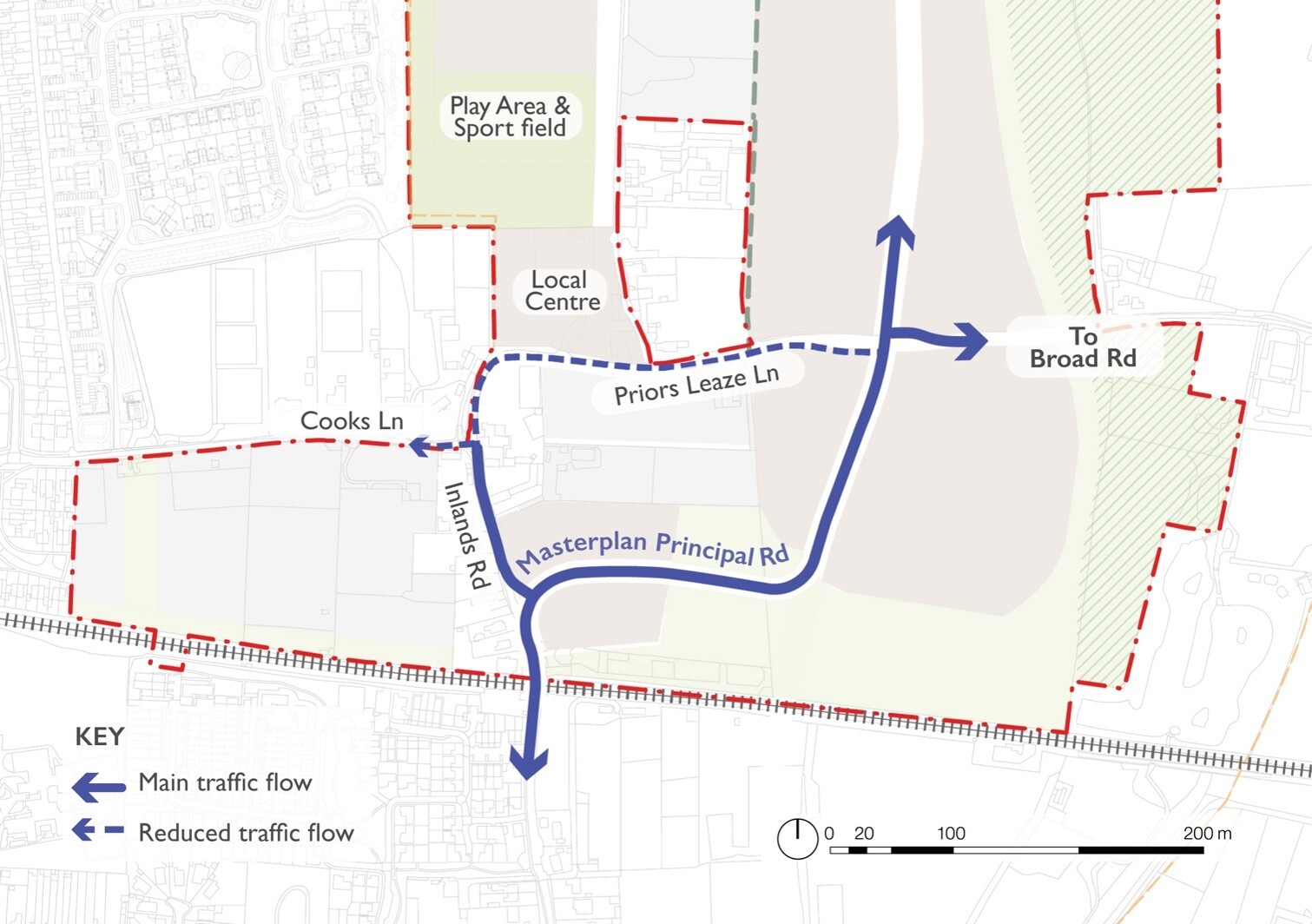
Figure 3 - diagram showing new highways arrangement de-prioritising Priors Leaze Lane
Climate change and moving towards net zero carbon living
5.31A key aspect of this site in terms of climate change adaption is its proximity to the railway station and encouraging sustainable travel choices. Consequently, ensuring a high degree of accessibility to the railway station is an absolute priority. High quality, well integrated, safe and highly useable walking and cycling routes are clearly integral to this process and must be delivered to the highest achievable standard.
5.32The development should be designed and constructed on the basis of the following sustainable design principles:
- Buildings should be compact in their form and should avoid overcomplicated forms including multiple dormers and bay windows to reduce heat loss and thermal bridging.
- Glazing should be optimised and large expanses of east/west facing glazing avoided. Where frontages overlook streets and open space and require larger window areas to create a positive street scene or outlook, windows should incorporate integrated screens to maximise solar gain.
- Shading should be provided to all west and south facing windows to limit summertime solar gain.
- Orientation of buildings should respond well to the local context and to the design approach and should maximise the opportunity for energy efficient homes. Cross-ventilation should be secured by maximising dual aspect homes.
- Roof design should be optimised for renewable energy generation.
- Where they are provided, heat pumps should be installed in a discrete location at the side or rear of the building. Where a location on the front is unavoidable, heat pumps should be incorporated into the design of the building and located in a robust and well-designed structure which is high quality and well-related to the overall design of the building.
Environment
Landscape strategy
5.33The landscape strategy underpinning the framework masterplan is predicated on the following overarching design principles:
- Adopt a multifunctional approach to open space with integration of green and blue infrastructure, play and recreation, nature and biodiversity;
- Create a linked landscape network with connected routes, street tree planting, formal and informal incidental spaces throughout the development;
- Adapt to and mitigate the impacts of climate change and reduce heat island effects through planting and the use of sustainable urban drainage systems.
Landscape Impacts
5.34Various landscape impacts have been considered during the preparation of this DPD. A key issue has been how the development will avoid settlement coalescence. This was initially explored in a landscape gaps study undertaken in 2019[2], and refreshed as part of the process of preparing this DPD. A landscape gap boundary, in order to avoid settlement coalescence, has been shown on the policies map and illustrated on the masterplan.
5.35It has also been essential to consider key views in relation to the South Downs National Park (SDNP) and the Chichester Harbour National Landscape, and also their settings. While these have been considered as part of the DPD preparation process, more detailed consideration will also be required in relation to the detailed design and layout of the development which comes forward as part of this allocation and this will need to be informed by an appropriate Landscape and Visual Impact Appraisal.
5.36These landscape features, particularly the SDNP, owing to its elevated character, create opportunities to create attractive views and vistas within the development, and conversely, particular consideration should be given to how the development will appear from key viewpoints within the SDNP.
Green Ring

Figure 4 - Image of Green Ring, taken from the SMNP p.47[3]
5.37The Green Ring is a key concept within the SMNP and by extension is a key principle underpinning the framework masterplan. The SMNP explains (in paragraph 5.62) that it aims to provide a means of mitigating pressure on the sensitive areas within the Chichester Harbour National Landscape by providing an alternative, compellingly attractive, seasonally dynamic walking, cycling and relaxing route served by benches sited to promote rest and reflection as well as sport and recreational features and other areas designed to promote spontaneous social interaction. It will also contribute to resolving the significant open space, sport and recreation deficit in the Parish. The framework masterplan sets out how the layout needs to support the provision of the Green Ring.
5.38The Green Ring should be an average of 20m wide but designed with local width variations to create spaces with varying function and character. It should be well connected to existing waking and cycling routes within the village, the new development, new cycle routes alongside the main street, existing public rights of way and large open spaces on the eastern and northern edges. It should incorporate:
- Shared walking and cycling routes (min 3m wide) as part of the active travel corridor;
- Play opportunities in the form of natural 'play-on-the-way' or play areas;
- Areas for nature, biodiversity and sustainable drainage; and
- Formal and informal seating opportunities.
5.39The development will deliver a section of the Green Ring alongside its western boundary. Together with the existing open space this section should be designed as a seamless, generous linear park.
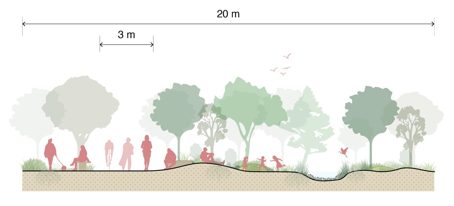
Figure 5 - diagram showing section of Green Ring
5.40Moreover, the masterplan effectively creates a multifaceted Green Ring in this location, with what is effectively an ‘internal route’ running along the western edge of the development, which essentially follows the route set out in the SMNP. However, there is also an additional route around the edge of the development on its eastern side. This significantly augments the original Green Ring concept.
Play, open space and sports provision
5.41The levels of open space provision within the parish were assessed in the council’s Open Space, Sport Facilities, Recreation Study and Playing Pitch Strategy - Open Space Update 2024, which formed part of the evidence base for the CLP. Southbourne has a notable deficiency of open space provision, pertaining to all of the typologies assessed in the study. This highlights the need for the new development to make adequate provision for new open space of all types in accordance with Policy P15 in the CLP.
5.42The masterplan includes the sports provision as part of an extensive community hub in the centre of the site. These will make a significant contribution towards the vitality of the new development, and the village generally. The location shown will allow the users of the sports facilities to utilise changing facilities to be incorporated into the community centre.
5.43A destination play area should be located adjacent to the local centre, recreation area and primary school. This should cater for all ages, including young children and activity for older children, such as MUGA, or activities for wheeling (skateboards and scooters). It should be of greater significance and interest. Secondary play areas are located at the periphery, where they are integrated into the wider landscape. The play strategy should be designed to incorporate all ages and sexes, including the consideration for ‘Space for Girls[4]’.
Nature, wildlife and biodiversity
5.44The natural environment is an important consideration which has been assessed in detail within the Assessment Framework and also the Habitats Regulations Assessment and Sustainability Appraisal (though all have somewhat different remits and frames of reference). The masterplan is shaped by the constraints along the eastern edge of the allocation area and ensures that the built form does not intrude into the wildlife corridor identified in the SMNP or the Strategic Wildlife Corridor in the CLP.
Suitable Alternative Natural Green Space (SANG)
5.45The masterplan incorporates a significant area of recreational open space, which has been provided in order to mitigate the recreational pressure related impacts on the Chichester and Langstone Harbours SPA. This will be located on the northern and eastern boundaries. Sensitive landscape design and careful consideration of routes will balance the needs of people and nature. The exact amount of space required will need to be established through the planning application process. This area should incorporate a 2.5km walking loop that connects to the Green Ring and public rights of way in order to provide choice and opportunities for leisure and dog walks.
Community Orchards and Allotments
5.46The development is required to provide a community growing opportunity in the form of allotments. To ensure these are easily accessible to the entire community these should be located adjacent to the Green Ring. The landscape design should also consider opportunities to integrate community orchards within the Green Ring.
Flooding
5.47As part of the process of producing the DPD the council commissioned a Strategic Flood Risk Assessment Level 2 (SFRA 2) in order to assess the flood risks pertinent to the BLD area. This provided a more detailed and fine-grained analysis than the SFRA Level 1 produced in relation to the CLP. It also provided an opportunity to set out necessary mitigation measures.
5.48Whilst the site allocation is generally at a low risk of flooding, a series of mitigation measures are required:
- A site-specific Flood Risk Assessment (FRA) to assess the risk of surface water, and the access and egress arrangements.
- That development be placed outside of the areas at risk from surface water flooding.
- That a drainage system be incorporated to manage groundwater flooding.
- That infiltration rates to be assessed on site as part of a drainage strategy.
5.49Sustainable Urban Drainage System should be incorporated into the development and become an integral part of the landscape and open space strategy. Design principles include:
- Prioritise the use of swales and other open sustainable drainage features.
- Adopting a multifunctional approach and ensure that Suds benefit nature and people.
- Avoid security fencing around attenuation areas by designing slopes 1:3 or shallower.
- Maximise porous paving in parking areas where possible.
Wastewater
5.50The site falls within the catchment of the Thornham Wastewater Treatment Works (WwTW). Following on from the adoption of the new Local Plan, Southern Water has confirmed funding is in place to increase treatment capacity at that facility.
5.51In terms of the problem of surface water and rainwater run-off infiltrating the sewage system, this issue is addressed in the adopted Local Plan, as policy NE17 states that no surface water from new development may be discharged to the public foul or combined sewer system.
Character
Delivering character
5.52The new development should deliver high-quality, locally distinctive, highly sustainable homes that respond positively to Southbourne’s character and landscape setting. Relevant applications should demonstrate a thorough understanding of the local context in the Design and Access Statement, showing clearly how the positive attributes of the context have influenced all aspect of the design. The emphasis on understanding local context is not for the new development to necessarily replicate this existing context, but to be sensitive, and respond positively, to it. Typical character assets include: street types or functions; historic environment and heritage assets; building grain and layout; interface with the street; material palette; attractive views or outlooks and landscape; trees; hedgerows; and water features.
5.53Throughout the village, owing to its suburban development form and relatively low building heights a sense of openness prevails, supported by landscaped verges alongside streets and relatively large and consistent front gardens on many frontages. This open suburban character contrasts the enclosed lanes of the Prinsted Lane conservation area. Here a high degree of enclosure is supported by a lack of pavements, boundary walls and a variety of building setbacks with some buildings being located close to the carriageway.
5.54Both character areas should serve as inspiration for the development allocation and a variation in character should be delivered. A homogenous approach across the entire site is unsuitable.
5.55Housing should use locally distinctive materials (red brick, flint, and other traditional finishes) to reinforce local identity. Contemporary design should draw inspiration from nearby heritage assets and the Prinsted conservation area, integrating traditional forms and detailing in a modern context.
Density
5.56A design-led approach needs to be taken to density, but while being mindful of the need to make efficient use of land and achieve a sustainable form of development. Some key principles are:
- The development should be designed at an average density of around 35 dwellings per hectare and a mix of house types and sizes to support a diverse community. Density should vary between higher (50+ dph) and lower densities around 20 dph to ensure a variation in character. A homogenous density of 35 dph across the development should be avoided.
- Higher densities (at 50+ dph) should be concentrated around the local centre and within 10-minute walking distance from the station to maximise access to facilities and public transport.
- Lower densities (around 20 dph) should be positioned along the northern edge and overlooking the wildlife corridor, providing a sensitive transition to the surrounding landscape.
6. Monitoring
6.1. A monitoring framework is set out within the CLP with respect to the policies it contains. This DPD is effectively an additional delivery mechanism for some of those policies and consequently will be monitored as part of the process of monitoring the Local Plan more generally. This will be set out in the council’s Authority Monitoring Report.
6.2. Some additional monitoring is also likely to be required in relation to transport related issues. This will form part of the monitor and manage approach set out within the CLP. Further monitoring is likely to be required as part of the Vision and Validate approach to the transport related aspects of this DPD. Additional detail in this regard will probably need to be set out as part of the planning application process.
[2] https://www.chichester.gov.uk/media/32147/Landscape-Gap-Assessment-May-2019/pdf/1983_CDC_Gap_Report_May_2019.pdf?m=1562761352990
[3] This diagram has been included for illustrative purposes in relation to this DPD. However, it has been included within the SMNP and the weight to be accorded to it in decision making should be on that basis.