Southbourne Allocation Development Plan Document: Regulation 18 Consultation Main Document
Chapter 5: Site Scenario Options
5.1. This section focuses on the scenarios tested within the Southbourne Broad Location for Development (BLD) to deliver a strategic site allocation and assesses the development scenarios for each option.
5.2. To inform the site selection process three scenarios have been developed. These three scenarios have evolved with the overarching DPD objectives in mind and explore potential technical and delivery issues. Each scenario has capacity for about 800 homes and can deliver the requirements of emerging Policy A13 of the submission Local Plan for the BLD. Appendix A (Assessment Framework) provides a detailed summary of the site assessment process that has informed the assessment.
5.3. An important consideration is the amount of housing which still needs to be planned for on the basis of policy A13. The policy refers to 1,050 dwellings, which is in itself a reduction compared with the 1,250 stated in the Preferred Approach version of the submission Local Plan. The council's position has been to deduct newly consented dwellings within the parish from that figure. On that basis the number of dwellings which remain outstanding and hence need to be planned for in this DPD is approximately 800 dwellings, and consequently the scenarios discussed in the consultation documents are based on that figure.
Development and infrastructure assumptions
Housing
5.4. As part of the site assessment process, we have assumed an average density of 35 dwellings per hectare (dph) to calculate the overall land take needed for around 800 new homes. This average density assumes that some lower density areas can be provided at 25 dph and other areas up to 50 dph to ensure that development is not homogenous and creates variety.
Alternative Natural Green space
5.5. To ensure that the site scenarios do not cause harm to the Chichester and Langstone Harbours Special Protection Area (SPA) due to new housing development, the same principles have been applied as those outlined in the Solent Waders and Brent Goose Strategy (Policy NE7 in the submission Local Plan). It is important to note that mitigation for the loss of functionally linked habitats is distinct from the mitigation required to address adverse impacts on the SPA resulting from recreational disturbance affecting bird species. Suitable Alternative Natural Green (SANG) space will not be appropriate for addressing the loss of functionally linked habitats.
5.6. To provide Suitable Alternative Natural Green (SANG) space, based on 8 hectares per 1000 people and assuming 2.4 people occupying each dwelling, a total of 15 hectares would be provided for 800 homes. Part of this area may overlap with the policy provision for a Green Ring, although it is likely that Natural England will require this to be delivered as a single large space that can provide a walking route.
Biodiversity Net Gain (BNG)
5.7. It is assumed that a BNG of at least 10 per cent will be provided on-site within the available open space. There could also be an opportunity for off-site BNG to enable enhancements to adjacent Strategic Wildlife Corridors (SWC). A preliminary and detailed BNG assessment will need to be undertaken at a later stage as part of future planning applications within the site allocation.
Vehicular (multi-modal) crossing
5.8. The proposed allocation may safeguard land for future vehicular railway crossings depending on the scenario selected. Current evidence suggests that the bridge might be required to address traffic congestion if approximately 800 homes are delivered to the north of the railway. Concerns regarding the safety of existing road and pedestrian level crossings could also be addressed (partially or fully) by provision of a multi-modal bridge crossing.
5.9. Issues and delivery risks for the proposed vehicular crossings, include:
- Land ownership
- Viability in terms of funding for the railway crossing
- Delivery timeframe
- Negotiations with Network Rail
- Detailed technical design of a new bridge and reconfiguration of existing roads (Scenario 1 - Land to the West)
- Impacts on neighbouring development.
Pedestrian / cycle bridge
5.10. Across the scenarios there are opportunities to improve pedestrian and cycle connectivity, by either introducing new crossing points or improving the existing informal crossing points.
Scenario 1: Land to the West
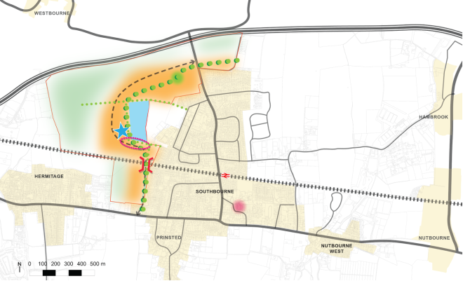
5.11. This scenario is located to the west of Southbourne and would deliver part of the Green Ring, provide consolidated education and leisure facilities and address the unsafe footpath (referred to as Church Crossing, with wicket gates) that crosses the railway.
- Site area: 88.8 ha (area within red boundary)
- Development area: 25.1ha (About 800 homes)
- Open space: minimum of 26.5 ha
Scenario 1: Land to the West
Benefits
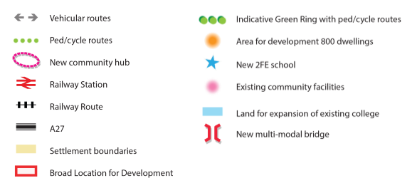
5.12. A new two-form entry (2FE) primary school and community centre could be located adjacent to the existing Bourne Community College. This could create a hub of activity for the village where facilities can be shared between the existing college and Bourne Leisure Centre with the new primary school and community centre, ensuring the use of the facilities are maximised. This option would create a safe community hub for children and the wider community and would benefit from having good connectivity to pedestrian and cycle routes within the Green Ring. There would also be multiple opportunities to create walking and cycle connections into the existing village.
5.13. This scenario explores the potential to address an existing unsafe pedestrian rail crossing by providing a pedestrian and cycling bridge and/or a vehicular bridge using access rights and land safeguarded through Section 106 Agreements from developments south of the railway.
5.14. This scenario allows the delivery of the western section of the Green Ring which integrates biodiversity, nature, wildlife and TPOs (Tree Preservation Orders) with Public Rights of Way and pedestrian and cycle connectivity.
5.15. A key benefit of this scenario is that the northern side of the site allocation could be largely facilitated by a single landowner, and land is safeguarded to the south of the railway line for a potential bridge (via existing S106 agreements), which would increase the deliverability prospects of the proposed development and provide more certainty over the delivery of a master planned and joined up approach to development. To the north of the railway line, land is currently safeguarded for future educational/leisure use which is in the ownership of West Sussex County Council. There are multiple landowners to the south of the railway line. Consequently, some additional co-ordination and negotiation with the different landowners is still likely to be required.
Challenges
5.16. A key challenge of this scenario is the need to accommodate an existing gas pipeline that runs through much of the north side of this scenario. If development cannot take place within this zone, this could potentially push development closer to the landscape gap addressed in the Landscape Gap Assessment completed for Chichester District Council in 2019. Landscape Gaps will be defined within the DPD Document.
5.17. Development in Scenario 1 involves an area identified as part of the gap from the Landscape Gap Assessment (CDC,2019). A landscape corridor at the western edge of this scenario will mitigate and provide a spatial and visual gap to the north of the railway line. In relation to the south of the railway this is addressed by a 100 metres landscape buffer; however more consideration and mitigation can be implemented through design.
5.18. This scenario relies on two vehicular access points for development to come forward. One access point would be required in the north at Stein Road and the other access point would be required in the south through a section of land safeguarded by a Section 106 Agreement (planning application ref: 15/02505 in relation to land west of Garsons Road). Parham Place Road was constructed in 2016 as part of planning application 15/02120 on Land East of 181 Main Road with access rights secured through a Section 106 Agreement. These two access points create a dependency on the delivery of a vehicular bridge and the cost and delivery timeframe are key considerations for this scenario. Additional vehicular access points south of the Southbourne College could potentially be achieved but rely on third party land.
5.19. If a pedestrian, cycle or multi-modal bridge is not delivered as part of this scenario then it will raise concerns about additional footfall from new development on the informal pedestrian level crossing at Church footpath. This is already considered as a high-risk crossing as confirmed by Network Rail.
5.20. This scenario has a direct impact on a Brent Geese Secondary Support Area which would need to be comprehensively mitigated as set out by the Solent Wader and Brent Goose Strategy Guidance on Mitigation and Off-setting Requirements Report of 2018.
5.21. Scenario 1 Summary
Benefits:
- Consolidated educational and community facilities creating a new community hub.
- Multiple opportunities to create walking and cycle connections into the existing village.
- Provides a pedestrian and cycling bridge and/or a vehicular bridge.
- Delivery of the western section of the Green Ring.
- The site scenario could be facilitated by a single landowner which increases the deliverability of the scenario.
- Potential to create characterful development through the retention of TPOs and PROWs.
- All development would be within proximity to quality green open space.
Challenges:
- Need to accommodate an existing gas pipeline consultation area to the north of the scenario where development may be restricted.
- Two access points proposed are largely dependent on the delivery of a vehicular bridge. If a multi-modal bridge is not delivered then it raises concerns about additional footfall and traffic from new development.
- Mitigation will be required for Brent Geese Secondary Support Area.
- Landscape buffer required to protect landscape corridor to the west of the scenario.
- Surface water flood risk issues are evident to the West of the BLD area to the north of the railway line.
- Greater percentage of land for development including the access road is located within the utilities consultation zone.
- The site would result in the loss of Grade 1 and 2 agricultural land.
5.22. Questions for Regulation 18 consultation: View responses
Q2. Do you agree with the list of benefits or challenges set out above?
Q3. Are there other benefits or challenges that you think should also be included?
Q4. In this scenario, what do you think would be the challenges or issues if there wasn't a vehicular bridge over the railway line?
Please set out reasons for the answers given.
Scenario 2: Land to the East
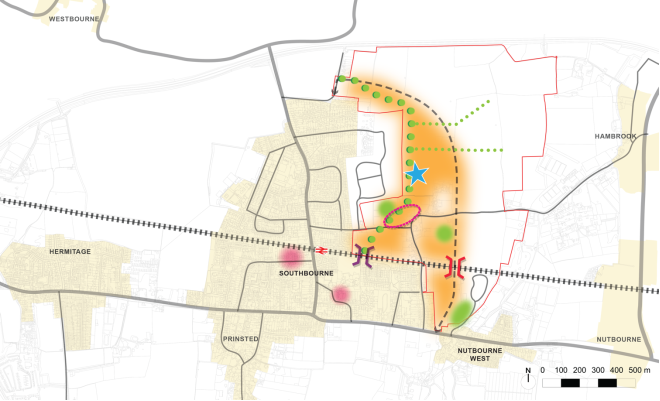
5.23. This scenario is located to the east of Southbourne and would deliver part of the Green Ring, improve pedestrian/cycle and vehicular connectivity and reduce pressure of the use of the rail crossing at Inlands Road, which has been identified as a safety concern by Network Rail.
- Site area: 109.4 ha (the area within the red line)
- Development area: 25.1ha (800 homes)
- Open space: minimum of 26.5 ha
Scenario 2: Land to the East
Benefits:
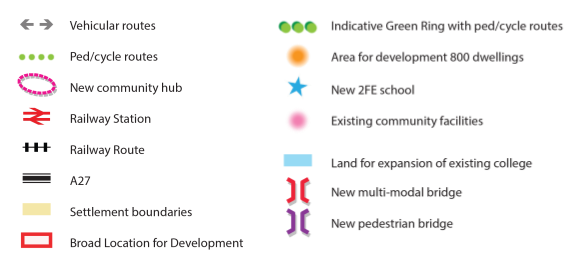
5.24. This scenario has the potential to deliver land for the pedestrian and cycle bridge within close proximity to the railway station using safeguarded land to the south of the railway. This scenario also envisions the delivery of a new vehicular bridge that would connect the A259 to Priors Leaze Lane through various parcels of land east of Inlands Road. This would relieve pressure from the crossing point at Inlands Lane, and congestion at the Stein Road crossing.
5.25. This scenario allows the delivery of the eastern section of the Green Ring, incorporating locally protected hedgerows and historic orchards and local green spaces.
5.26. The location of the new proposed primary school to the east of the village will spread out the educational facilities within Southbourne, distributing traffic across the village. This location for the new primary school would also be able to connect to the Green Ring, benefiting from easy access to nature and pedestrian and cycling routes.
5.27. The proposed development would retain a landscape corridor to the wildlife area to the east and has the ability to integrate existing water courses within a blue and green infrastructure strategy. A landscape corridor at the eastern edge of the scenario provides a spatial and visual gap north of the railway line. Development in the eastern scenario does not involve land identified as part of the gap from the Landscape Gap Assessment (CDC, May 2019).
Challenges:
5.28. A key challenge of this scenario, similar to Scenario 1, is the need to accommodate an existing gas pipeline that runs through much of the north side of this scenario. The pipeline and consultation zone extends over the northern access point that would connect the development to Stein Road. Therefore, proposals for an access road would need to be consulted on.
5.29. This scenario has a strong reliance on a vehicular bridge over the railway line which is challenged by a live planning application (ref: 24/01161) for 46 dwellings, which was submitted in July 2024 and has not been determined. This application site is situated to the south of the railway line and does not safeguard land for an access road and vehicular bridge over the railway crossing. Further consultation and discussions with the landowner will be required to facilitate this access point. This is further challenged by the cost and delivery timeframe for the vehicular bridge.
5.30. If a pedestrian, cycle or multi-modal bridge cannot be delivered as part of this scenario then it will raise concerns about additional traffic (pedestrian, cyclist and vehicular) from new development on the Inlands Road level crossing which has been raised as a concern by Network Rail.
5.31. A secondary vehicular access point using South Lane to connect to Stein Road may not be appropriate for a main access point because of existing considerations such as width of the lane and historic hedgerows. It would require further technical work and to consider the hedgerows and landowners of adjacent land to expand the road.
5.32. This scenario includes multiple landowners and planning applications and pre-application submissions have started to come forward for development. As has been alluded to above, these applications are predicated on the sites being developed in isolation. Therefore, a key challenge with this scenario would be ensuring that development comes forward in a coordinated and comprehensive manner.
Benefits:
- Potential to deliver land for a multi-modal bridge and a bridge for pedestrians and cyclists within close proximity to the railway station.
- Delivery of the eastern section of the Green Ring.
- Opportunities to create walking and cycle connections into the existing village.
- Location of the proposed new primary school to the East of the village does not consolidate facilities but will spread out the educational facilities within Southbourne, distributing access to the facilities more evenly across the village.
- A landscape corridor at the eastern edge of the scenario provides a spatial and visual gap north of the railway line.
Challenges:
- Need to accommodate an existing gas pipeline consultation area to the north of the scenario where development may be restricted.
- Strong reliance on a vehicular bridge being provided over the railway line which is challenged by land not safeguarded for access.
- If a multi-modal bridge is not delivered, then it raises concerns about additional footfall and traffic from new development.
- Multiple landowners make the deliverability of this scenario more challenging and the lack of any apparent joint working between the developers to deliver a coherent solution is a significant concern with this option. Development would need to come forward in a coordinated and comprehensive manner. Applications which have already come forward have significantly compromised this option. Any further significant applications brought forward in isolation within this area could make any proper master planning of this option unachievable.
- Would result in the loss of Agricultural Land Grades 1 and 2.
- Flood risk issues in parts of the east of the BLD area where no development can be planned and a buffer to development is required. There is a crucial surface water drainage area where the potential bridge would be located and the southern vehicular access point would be within a future flood zone.
5.34. Questions for Regulation 18 consultation: View responses
Q5. Do you agree with the list of benefits and challenges set out above?
Q6. Are there other benefits and challenges that you feel should also be included?
Q7. In this scenario, what do you think would be the challenges or issues if there wasn't a vehicular bridge?
Please set out reasons for the answers given.
Scenario 3: Mixed Scenario
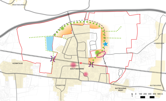
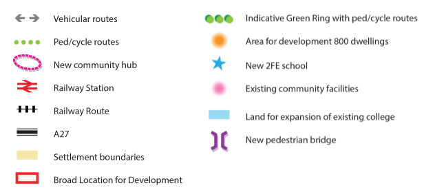
5.35. This scenario is a mix of both scenarios that distributes development between the east and west of Southbourne. This scenario delivers most of the Green Ring, providing new educational facilities and provides safe pedestrian and cycle access over the railway line but not vehicular access.
- Site area: 198.2 ha (area within the red line)
- Development area: 25.1ha (800 homes)
- Open space: minimum of 26.5 ha
Scenario 3: Mixed Scenario
Benefits:
5.36. This scenario minimises risks regarding access and delivery as it does not propose to build a multi-modal bridge, and maximises land that is more readily accessible with the main access proposed from Stein Road into land to the east and west.
5.37. A key benefit of this scenario is that it has the ability to deliver an almost complete Green Ring which integrates biodiversity, nature, wildlife and TPOs (Tree Preservation Orders) with Public Rights of Way and pedestrian and cycle connectivity.
5.38. The location of the new proposed primary school to the East of the village will spread out the educational facilities within Southbourne, distributing traffic across the village. This location for the new primary school would also be able to connect to the Green Ring, benefiting from easy access to nature and pedestrian and cycling routes.
5.39. This scenario has the potential to deliver a pedestrian and cycle bridge using safeguarded land south of the railway to create a safe crossing close to the station and relieve pressure from Stein Road level crossing.
5.40. This scenario creates a more balanced spatial growth pattern that is aligned with the shape and form of Southbourne. It also maintains the recommended spatial and visual gaps by the Landscape Gap Assessment (CDC, 2019) to avoid merging with surrounding settlements. This scenario spreads development around Southbourne which would retain flexibility for future growth of the village if required.
Challenges:
5.41. The existing gas pipeline that runs through much of the north side has a consultation zone of 120m that is considered a risk to the scenario as it goes through the northern access point that connects the development East to West. Therefore, proposals for an access road would need to be consulted on.
5.42. This scenario also has an impact on the Brent Geese Secondary Support Area which would need to be mitigated as set out by the Solent Wader and Brent Goose Strategy Guidance on Mitigation and Off-setting Requirements Report of 2018. However, this would have a smaller impact when compared with Scenario 1.
5.43. Whilst this scenario spreads development around Southbourne and hence reduces the pressure for a multi-modal bridge over the railway crossing, it will still raise concerns about the capacity of the local road network to accommodate the additional traffic, particularly in relation to the Stein Road and Inlands Road Level Crossings and the narrow country lanes in the locality. In addition, there would also be addition pressure on the informal pedestrian level crossings at the Church footpath and Penny Lane footpath identified by Network Rail. Development around Inlands Road has been raised as a concern by Network Rail unless a bridge is provided to alleviate pressure on existing level crossing.
5.44. Similar to Scenario 2, there are multiple landowners and planning applications, and pre-application submissions have started to come forward for development. Therefore, a key challenge with this scenario would be ensuring that development comes forward in a coordinated and comprehensive manner. This option is likely to be even more problematic than scenario 2 in relation to land assembly, co-ordination of land-owners and land equalisation, as it would require all the landowners within the BLD to be part of that process.
5.45. Scenario 3 Summary
Benefits:
- Minimises deliverability risks regarding access as it does not propose to build a multi-modal bridge.
- Proposed development would be more evenly distributed around the village.
- Ability to deliver an almost complete Green Ring.
- Similar to the east and west scenario options, this scenario retains landscape corridors to the east and west of the wildlife areas.
- Multiple opportunities to create walking and cycle connections into the existing village.
- Location of the proposed new primary school to the east of the village does not consolidate facilities but will spread out the educational facilities within Southbourne, distributing access to the facilities more evenly across the village.
- Potential to deliver a pedestrian and cycle bridge using safeguarded land south of the railway to relieve pressure from Stein Road level crossing.
Challenges:
- Need to accommodate an existing gas pipeline consultation area to the north of the scenario where development may be restricted.
- Mitigation will be required for Brent Geese Secondary Support Area.
- Does not provide a vehicular bridge over the railway line and therefore may increase impacts of traffic congestion at existing crossings due to new development.
- Multiple landowners make the deliverability of this scenario more challenging. Development would need to come forward in a coordinated and comprehensive manner.
- Would result in the loss of agricultural land Grades 1 and 2.
- Surface water flood risk issues are evident to the West of the BLD area to the north of the railway line, which could have implications for the pedestrian bridge which would be needed.
5.46. Questions for Regulation 18 consultation: View responses
Q8. Do you agree with the list of benefits and challenges set out above?
Q9. Are there other benefits and challenges that you feel which should also be included?
Please set out reasons for the answers given.
5.47. Question for Regulation 18 Consultation View responses
Q10. Which scenario do you feel should be selected as the preferred option for allocation? Please rank from 1st (most preferable) to 3rd (least preferable).
Please set out the reasons for your ranking.