Southbourne Allocation Development Plan Document: Regulation 18 Consultation Assessment Framework
2.1. The purpose of this chapter is to provide an overview of the key technical constraints and influences. This section of the report considers the wider context of the Broad Location for Development (BLD). It identifies the characteristics of Southbourne and its surroundings, all of which have the potential to influence both the site selection process and how the elected site should be developed.
2.2. An evidence-based appraisal has been carried out for each theme of influence. A comprehensive understanding of Southbourne and its context is the starting point for both assessing the site allocation options and establishing which is the most suitable option.
About Southbourne
2.3. Southbourne is the largest settlement within Southbourne Parish, located in the west of Chichester District within West Sussex. The parish also comprises Prinsted (part of the Southbourne settlement boundary) Hermitage, and Nutbourne West, which all benefit from their proximity and access to the services and facilities provided in Southbourne. The settlements of Emsworth, Westbourne and Chidham and Hambrook are also close by, within neighbouring parishes or districts.
2.4. Southbourne lies immediately south of the A27, a dual carriageway and part of the strategic road network. The A259 Emsworth to Chichester Road and the West Coastway railway line (providing connections to Chichester, Portsmouth, Southampton and London) both cross through the settlement from east to west. The settlement benefits from a centrally located train station on Stein Road.
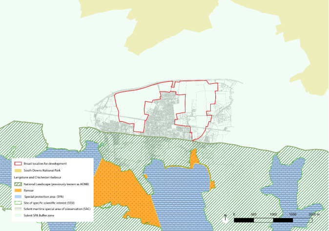
2.5. Southbourne is positioned between two distinct landscapes. The South Downs National Park to the north, and the Chichester Harbour to the south, which contains a range of statutory designated habitats. The habitats include:
- Chichester and Langstone Harbours Special Protection Area: this designation is part of the EU Birds Directive, protecting vital habitats for migratory birds such as waterfowl and waders.
- Ramsar Site: Chichester and Langstone Harbours are recognised under the Ramsar Convention as wetlands of international importance for their support to a variety of wildlife.
- Solent Maritime Special Area of Conservation: This SAC designation protects marine habitats and species, ensuring that these environments are conserved and enhanced.
- Chichester Harbour Site of Special Scientific Interest: This designation highlights the site's national importance for conservation, safeguarding its biodiversity, particularly for its habitats.
2.6. Southbourne has a population of around 6,820 people as noted in the submission Local Plan 2021-2039 evidence base.
2.7. Southbourne has a range of characteristics that have been analysed in the evidence base of the submission Local Plan. These inform the identity of the village as well as the opportunities that relate to the new allocation for the BLD. These characteristics are grouped into themes:
- Settlement history, form, built and landscape character
- Land uses and land ownership
- Natural environment and influences
- Movement network.
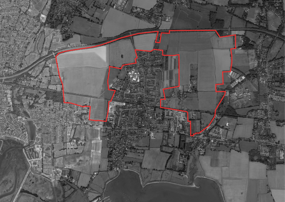
Figure 2.1. Proposed extent of BLD, as identified within Chichester Local Plan 2021-2039 Southbourne Broad Location for Development Background Paper (May 2024).
Settlement history, form and character
History
2.8. Historically, Southbourne developed alongside an ancient Roman Road which connected Chichester to Portchester, known today as Main Road (now the A259). The junction with Stein Road became the nucleus for development of the village. The growth of the village was largely related to the arrival of the railway station in 1906 which is still being used. During and after World War Two, many council houses were built, and an aerial base station was created for bombers of the United States Army. This was eventually converted into a school, new homes and the current employment zone. This housing growth has led to a variation in character with pockets of development representative of its time.
Heritage Assets
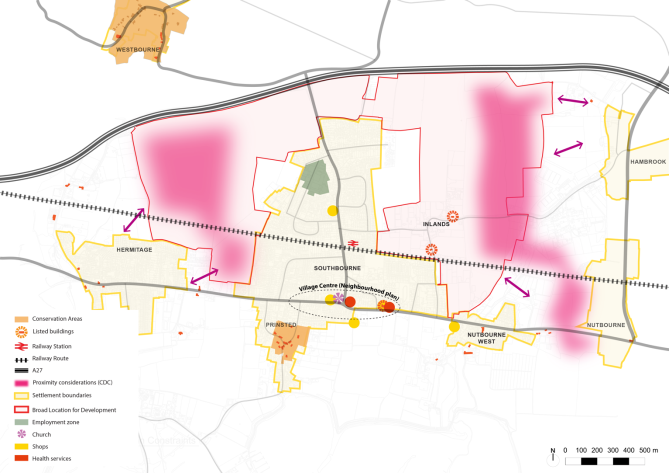
2.9. A review of Historic England's National Listings indicates that the settlement of Southbourne benefits from two Grade II listed buildings, both of which are described below. The two designated heritage assets are located within the BLD. Any development that comes forward must have due regard to the character and setting of these heritage assets.
2.10. Thatchways, located on Inlands Road, is a Grade II listed cottage recognised for its architectural and historic significance, representing a well-preserved example of a traditional domestic structure within the region. The listing emphasizes the facades faced with flints with red brick, hipped thatched roof, casement windows, and doorway with thatched hood. The house likely dates back to the 17th or early 18th century, reflecting the craftsmanship and materials of that period. The overall design is harmonious with its rural setting, making Thatchways a significant example of traditional architecture in the region.
2.11. Loveders Farmhouse, located on Priors Leaze Lane. The farmhouse likely dates back to the 17th or early 18th century and features a timber-framed structure with brick infill, a common characteristic of historic rural buildings in this area. The roof is pitched and covered in clay tiles. The design includes large, prominent chimneys, casement windows, and a well-proportioned, symmetrical facade that contributes to its historic character. The building's materials and construction techniques reflect the local craftsmanship of its time, making it an important example of the region's architectural heritage.
2.12. Prinsted Conservation Area is located to the south of Southbourne and is known for its rich historical and architectural significance. It features traditional cottages, historic farmhouses, and listed buildings. The area maintains its rural charm with narrow lanes and a proximity to Chichester Harbour, which offers scenic views and supports diverse wildlife. Noting the separating distance between Prinsted and the BLD, it would be reasonable to conclude that there is unlikely to be any significant impact by virtue of future development within the BLD.
Landscape and Built Character
2.13. Southbourne village is characterised by its rural identity and open landscape features, with large exposed arable fields enclosed by historical hedgerows on a low-lying coastal plain. The village is serviced by a main axis road (Stein Road) where development has been concentrated. This has created a suburban character around Stein Road of terraced and semi-detached houses, mostly made of red brick with some other variation of materials such as flint.
2.14. The village centre is located at the southern junction of the village at Stein Road but amenities and services have been distributed throughout the village. The shape of the settlement spreads out to the east with Inlands Road and north with South Lane, where the character of the landscape and the dwellings become more spacious, there are more detached houses and more greenery.
2.15. To the east of the village, there is a stronger historical character with two listed buildings, narrow and winding lanes, some from Roman times, and ancient hedgerows and orchards. The landscape of hedges and tree lines provide visual containment that frames certain views and creates a rural character. In winter months there are clearer views to the hills of South Downs National Park, and to the undeveloped countryside of the coastal plain leading up to the harbour and National Landscape. The low-density settlement to the south-east and the natural landscape provide a perceived separation to the neighbouring settlement of Nutbourne West which lies considerably close in proximity.
2.16. To the west of the village, the roads are wider, the residential area is compact and borders with wide open fields of land enclosed on the edges by a network of low hedgerows. The openness in character of the west is also attributed to unrestricted views to the north to the South Downs National Park. A key view in the west is the church spire which is visible from the area south of the railway, but this is not a listed building.
2.17. More recent developments have expanded the shape of the village, particularly to the east. Small developments have filled in gaps in the urban form with suburban arrangements of cul-de-sac roads and semi-detached houses. They follow a similar design in terms of architectural materials and height, with gable roofs, referring to architecture found around the village.
Form
2.18. An important factor which will influence how the form of the village evolves is the A27, which forms a linear barrier to the north of the village. Another important factor is potential coalescence with neighbouring villages as indicated by Chichester District Council's Landscape Gap Assessment (May 2019) which forms part of the submission Local Plan evidence base. The current shape of the settlement is more compact in the centre but becomes less dense at the periphery of the village. The gaps shown in the plan below are provided as a recommendation from the Landscape Gap Assessment to avoid urban sprawl and maintain separation between settlements.
Figure 2.2 Built Form and Heritage.
Land uses and land ownership
Land Uses
2.19. The predominant land use in Southbourne is residential and agricultural land but there are a range of services within the village centre which comprises a church (built in 1876), a historical public house (the Travellers Joy, built in 1656), as well as essential local services such as a chemist, a doctor's surgery and an undertaker, among other local retail uses to the north.
2.20. As identified in the submission Local Plan, Southbourne has limited opportunities for employment. Currently, the retail shops and employment areas are the main sources of employment. The employment area comprises moderately sized industrial units/warehouses to the north of the railway line that remain active with office uses and car repair businesses.
2.21. Education services are mainly provided by Southbourne Community College which is located within proximity to a modern leisure centre. There is a primary school, two nurseries and an education centre (Tuppenny Barn). Tuppenny Barn is a charity that teaches children to eat and grow their own organic food. There are other community facilities dispersed throughout the village including a library, a community hall, playing fields, and a 'men's shed' which is a community centre focused on workshops for men.
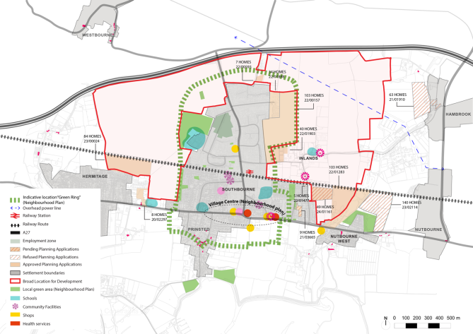
2.22. There are currently four residential development sites located within the proposed BLD area for which planning applications have been submitted and approved since the Regulation 19 consultation on the submission Local Plan, as shown in the figure below.
Figure 2.3 Land uses map
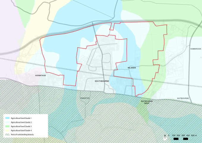
2.23. Figure 2.4 below shows the different agricultural land classifications at Southbourne. Natural England identifies the land as agricultural land grade 1, 2 and 3, as per the Regional Agricultural Land Classification Maps. The BLD is also located within a nutrient neutrality catchment area due to its location near a SPA. Nutrient neutrality requires that new housing developments in certain areas should not add more 'nutrient pollution' to the water catchment. This only applies to new housing developments in areas with protected habitat sites.
Figure 2.4 Agricultural Land Classification
Land Ownership
2.24. Based on the availability of land having regard to the CDC Housing and Economic Land Availability Assessment 2021 (HELAA), development to the west considers multiple landowners at both north and south of the railway line. Additionally, there is land safeguarded by Section 106 agreements (application ref: 15/02505/OUT and 15/02120/FUL) for the purposes of enabling access from the A259 (shown in green in Figure 2.4). Land assembly to the east comprises multiple landowners as demonstrated in figure 2.5 below.
Figure 2.5 Land Ownership plan
Natural influences
2.25. The Broad Location for Development (BDL) is characterised by various forms of legislative protection and conservation-related planning policies. These include flood zones, areas of high-quality landscape and wildlife value. This section analyses potential impacts on protected landscapes and habitats, as well as locally valued landscape features, and ambitions to create future landscape and habitat connectivity.
2.26. South Downs National Park (SDNP) is located to the north of Southbourne and Chichester Harbour National Landscape (CHNL) is located to the south. The wider scale influences must consider the impact to the CHNL located to the south of the A259 road and to the SDNP to the north. Development has the potential to result in visual impacts and could disrupt scenic views towards Chichester Harbour National Landscape and South Downs National Park. Poorly integrated development could erode the distinctive rural character of the Southbourne area. Any development in Southbourne should include sensitive design principles, landscape buffers, and ecological protections, ensuring harmony with the natural environment. Careful planning is essential to avoid detrimental effects on both the views and ecological quality of the National Landscape and National Park.
2.27. Chichester Harbour is also a Special Protection Area (SPA) for waterfowl, and regularly supports an assemblage of at least 20,000. Chichester Harbour Site of Special Scientific Interest (SSSI) and Ancient Woodlands are noted as irreplaceable habitats. There is a requirement to protect wintering bird feeding and roosting areas from recreational disturbance. The SDNP is also a SSSI and Special Area of Conservation (SAC). The Chichester and Langstone Harbours SPA is located on the south coast of England in Hampshire and West Sussex. The Ramsar Site is located within the setting of the CHNL. It provides critical habitat for numerous bird species, particularly migratory waterfowl and waders. It supports species such as brent geese, dunlin, redshank. The site encompasses a range of important habitats which essential for feeding and roosting birds, as well as other wildlife. The site is also part of the Solent Maritime SAC and an SSSI. These designations emphasise the ecological significance to ensure its protection.
2.28. Due to being in the proximity of the SPA, development proposals will need to accord with policy NE7 of the submission Local Plan, which considers development within the zone of influence to likely have an effect on the SPA, would be subject to the provisions of Regulation 63 of the Conservation and Habitats and Species Regulations 2017 (as amended). Additionally, development would need to pay due regard to submission Local Plan policy NE19 whereby it will demonstrate that it would be nutrient neutral for the lifetime of the development.
2.29. Adjacent to the BLD are two Strategic Wildlife Corridors identified and proposed within the submission Local Plan 2021-2039 (Policy NE4 refers) to ensure connectivity between the SDNP and Chichester Harbour. This is also supported by the Southbourne Modified Neighbourhood Plan 2014-2029, which identifies the Hambrook Chalk Stream Wildlife Corridor and Lumley Stream Wildlife Corridor through its policies map, which encompasses a wider area.
2.30. These designated wildlife sites protect local species networks such as waders, bats and water voles. Natural England has identified an area of the BLD as a secondary support area for Solent Waders and Brent Geese to the west in HELAA site HSB0047.
2.31. Local green spaces within reach of the BLD are identified in the Neighbourhood Plan as Memorial Stand and Southbourne Fields Development. Other identified natural assets in the BLD include trees protected by preservation order (TPO), Ancient Woodland, traditional orchards (provisional) and hedgerows.
Figure 2.6 Wildlife Influences
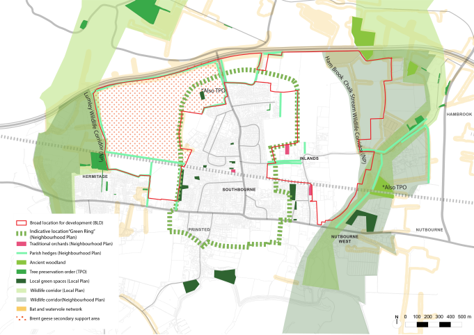
Figure 2.7 Designated Landscapes and Habitats
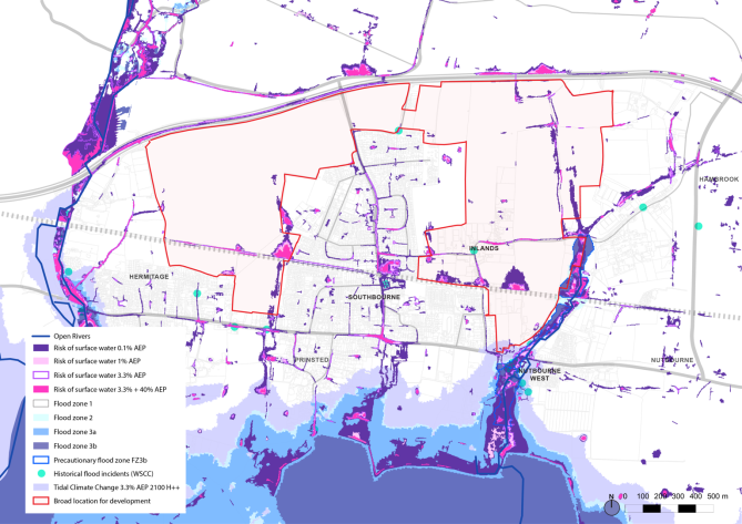
2.32. A chalk stream, Ham Brook, runs along the eastern boundary of the BLD area, and to the west is located Lumley stream. The land running alongside Ham Brook is also a Flood Zone 2 area. This feature needs to be carefully considered in relation to the impact on the natural environment, with a 50-buffer likely to be required. It also needs to be considered in relation to flood risk. In terms of other flooding constraints, the BLD area is also impacted by surface water, particularly to the north of the railway line on the western and eastern sides of the BLD, and other smaller areas throughout the BLD. There is a Nutbourne Flood Study (2019) that states that the potential impacts of groundwater flooding should be investigated, and mitigation measures provided to reduce flood risk, however, groundwater is a difficult form of flood risk to plan for and further investigation of this issue is likely to be required. There is also a future tidal flood risk area on the eastern side of the BLD which will impact on access options in relation to the A259.
Figure 2.8 Flood Map
Connectivity Network
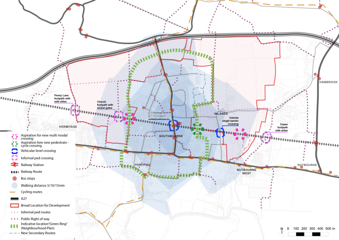
2.33. The village is considered to have good transport links to the wider areas, however, it is challenged by the severance of the railway across the settlement and its immediate surroundings. The Stein Road junction on the A259 offers opportunities to supplement and reinforce the existing public transport including bus routes and cycling paths. There are plans to improve the junction and deliver dedicated cycle lanes.
2.34. The village is connected by existing cycle routes, including part of the National Cycle Network Route 2, which follows the A259, connecting Chichester and Emsworth (the ChEm Route). A north to south linear cycling route that runs through Stein Road connects to A259.
2.35. In terms of pedestrian connectivity and walkability the Public Rights of Way (PROW) network has clear paths that go around the edge of the settlement. These connect to informal pedestrian paths found in evidence provided by the Parish Council. The village is mostly walkable from the train station in a 15-minute radius.
2.36. Connectivity within the village is challenging due to the severance of the village by the railway, particularly for connectivity due to the lack of crossings from north to south. It has resulted in three informal pedestrian level crossings, about which there are safety concerns, particularly to the west of Southbourne where Church Crossing is used to access the secondary school and leisure centre from the south.
2.37. At present, there are two road level crossings, the main one being located on Stein Road, which is an automatic double barrier. Safety risks have been identified for the Inlands Road level crossing due to its automatic single barrier crossing with no physical surveillance. The level crossings create frustration within the community, as expressed by the Parish Council, due to the congestion caused by the barriers closing.
Figure 2.9 Connectivity and Movement Plan
Opportunities and Constraints
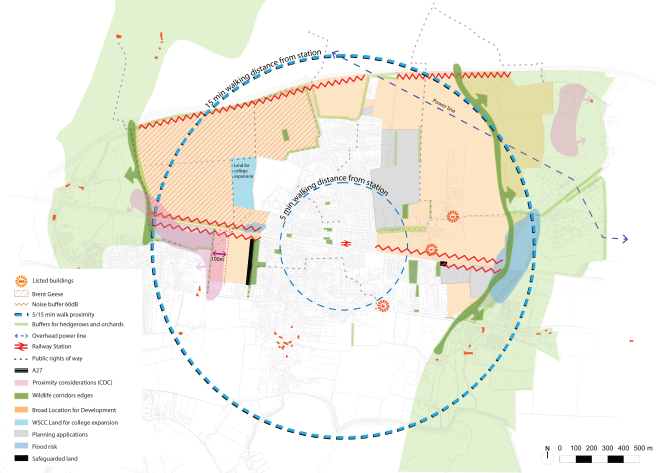
3.38. The opportunities and constraints identified in the BLD area summarised in figure 2.9, have helped to inform the site assessment process for the site scenario options which will be assessed as part of the Site Assessment Framework that will guide the formation of the final Site Allocation DPD.
Figure 3.0 Constraints Map
Constraints
- There is an overhead power line and electricity pylons that will need a 60-metre buffer to development on each side, located to the east of the village. There is a gas pipeline which runs through the north of the Southbourne BLD area which has a consultation buffer of 120m (60m each side).
- There are two Grade II Listed designated heritage assets of which any development that comes forward must pay regard to the character and setting of these heritage assets. Thatchways, located on Inlands Road, is a Grade II Listed Cottage, and Loveders Farmhouse, located on Priors Leaze Lane. These are described in detail on Page 9 and Fig 2.2. Any form of development that comes forward must consider their setting and character.
- The BLD contains Grade 1-3 agricultural land is classified as some of the best agricultural land in the country. Developing on this land results in the permanent loss of a valuable resource for food production and farming, which is generally discouraged by planning policies.
- Impact on views to the Chichester Harbour National Landscape to the south of the A259 and views to the north towards the South Downs National Park.
- Strategic Wildlife Corridors are proposed adjacent to the BLD area to protect local species networks such as waders, bats and water voles.
- Natural England has identified an area in the west of the BLD area as a secondary support area for Brent Geese.
- There is a TPO and Ancient Woodland in the BLD area. There are also traditional orchards which should be preserved where possible. These are designated green spaces as per Southbourne Neighbourhood Plan Policy SB16.
- Existing and future flood zones in the east and surface water flooding to the north of the railway in the east and west are evident in the BLD area.
- Potential coalescence and sprawl with neighbouring villages and maintaining a visual gap between settlements.
- Dispersed location of amenities means that Southbourne lacks a clearly identifiable centre of activity.
- Unsafe and uncontrolled pedestrian rail crossings such as Inlands Road crossing and western PROW (public right of way) crossings.
- Limited crossing points and highway capacity restrictions to the existing level-crossing on Stein Road. This causes congestion at Stein Road.
- Noise and air quality associated with the A27 Road and noise constraint from railway line as identified within Regulation 14 consultation responses to Noise and Vibrations Evidence Base, and the Air Quality technical note provided by Wates in 2020.
- Lack of positive walking and cycling connections within the village due to the severance by the railway line.
- Multiple landowners in the east of the BLD area may cause delivery and land ownership issues. There is potential for a lack of a coordinated approach given the planning applications that have already been submitted in this area.
Opportunities
- Potential to improve highways and infrastructure connectivity and reduce congestion through engineered solutions such as a new bridge(s) over the railway line.
- Wider landscape and ecology designations provide good access to nature for future residents.
- Potential to help deliver Green Ring and wider ecological improvements to mitigate development.
- Potential to improve and provide new amenities and local community facilities within the site allocation and throughout the village through financial contributions resulting from new development.
- Provide new or upgraded walking and cycle connections by delivery of new pedestrian and cycle bridge addressing north-south mobility within the village.
2.39. Question for Regulation 18 consultation: View responses
Q11. Do you agree with the list of opportunities or constraints set out above?
Q12. Are there any others which should be mentioned in relation to either category?