Adopted Local Plan 2021-2039
Appendices
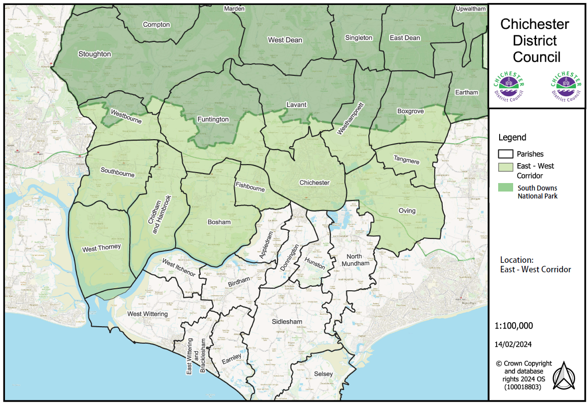
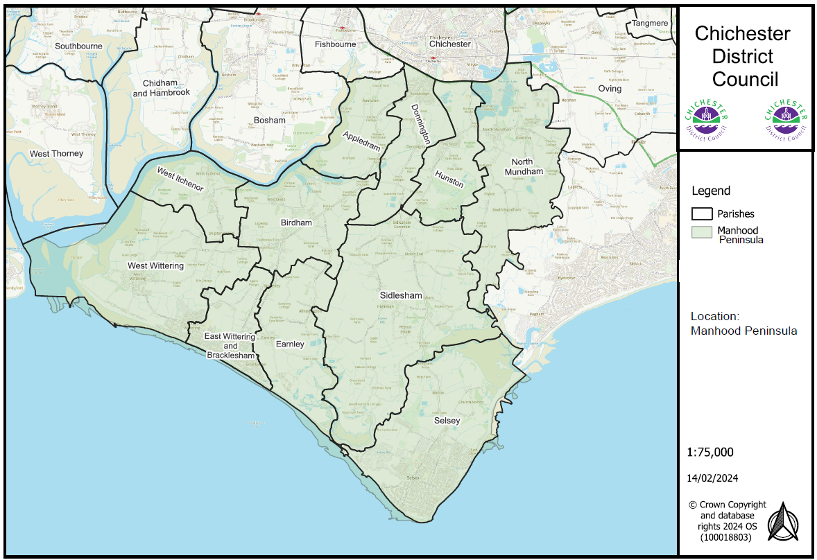
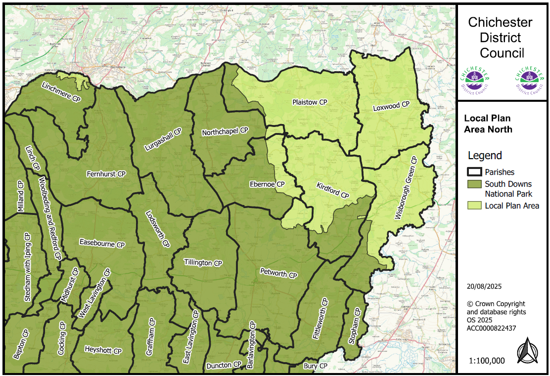
Appendix A: Plan Area sub-area maps
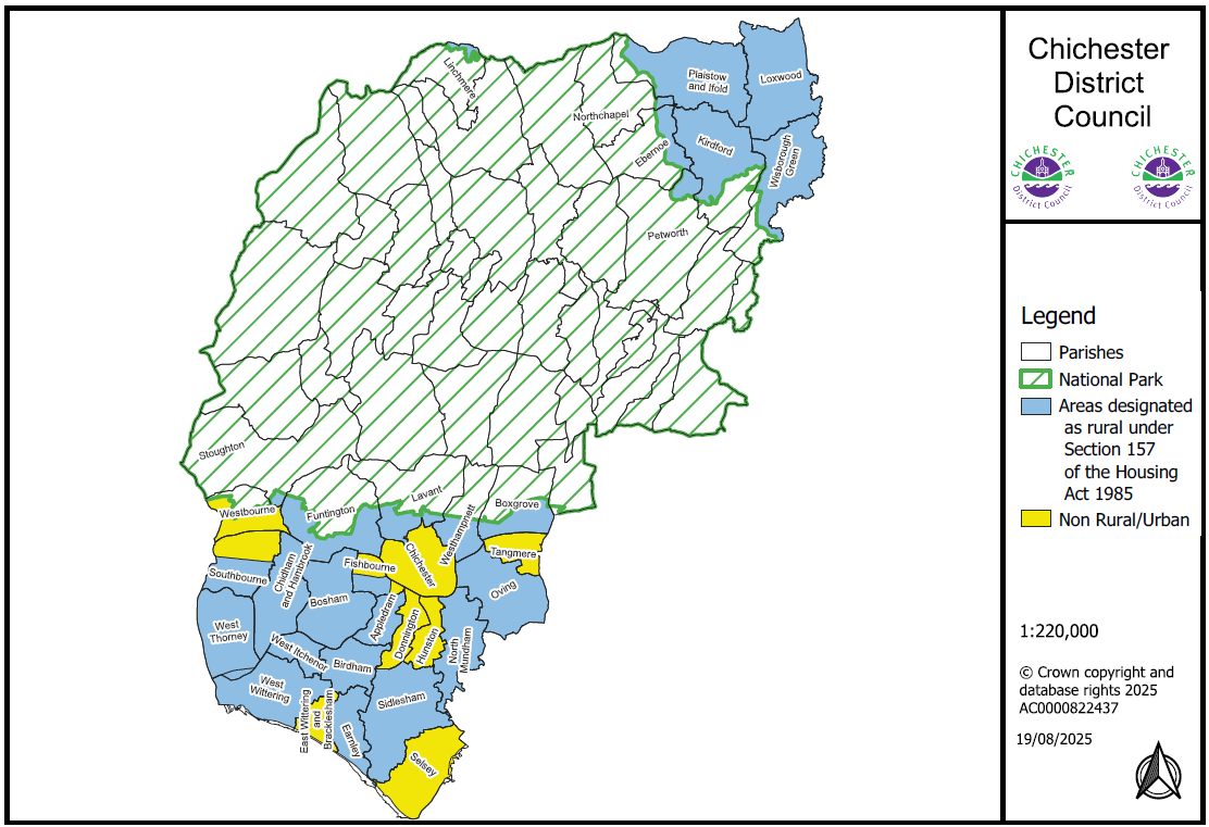
Appendix B: Plan Area Map of designated rural areas
Appendix C: Additional Guidance
The appendix below is included because it is referred to in several of the policies included in this schedule and provides further information on marketing requirements and evidence to be submitted in support of planning applications.
Appendix C – Additional Guidance
Marketing Guidance and additional information required to support planning applications
Introduction
C.1 Applications for some changes of use or redevelopment of property/land need to be accompanied by evidence that sufficient marketing has taken place before concluding that the property/land is no longer required for its current use, or preferable alternatives to that proposed. This appendix gives guidance on the marketing evidence and additional information to be provided. Policies contained in the Local Plan to which this guidance relates are:
- Policy H8 - Specialist Housing
- Policy H9 - Accommodation for Agricultural, Horticultural and other Rural Workers
- Policy P17 - New and Existing Local and Community Facilities including Local Shops
- Policy E2 - Employment Development
- Policy E6 - Chichester City Centre
- Policy E7 - Local Centres
- Policy E8 - Built Tourist and Leisure Development
- Policy E9 - Caravan and Camping Sites
- Policy NE11 - Development in the Countryside
Proportional Approach
C.2 This appendix sets out the usual minimum standard of marketing. It is however recognised that any marketing should be proportionate to the size and characteristics of the site/property and the scale of the proposed alternative use. Before beginning a marketing campaign applicants should contact the council to agree the length and nature of marketing required and to discuss the extent of alternative uses to be explored.
General Requirements of Marketing
C.3 It is important that the marketing of the land, buildings or a site(s) explores appropriate alternative uses; that the marketing price is competitive (set by an independent valuer with relevant qualifications); the marketing has been appropriate and genuine; and that a record of all the marketing is presented with the application proposal. The type and scale of marketing should be commensurate with the scale of the facility proposed to be lost.
C.4 A marketing report should be submitted as part of any relevant planning application, to demonstrate that a robust marketing strategy has been followed. Unless material considerations justify otherwise, or a different period has been agreed with the council, the marketing report should include evidence that the site has been continuously marketed for at least 1 year, and an appropriate amount of time according to the market conditions. The period of marketing should not have ended more than 3 months prior to the date the planning application was submitted.
C.5 The marketing report must include as a minimum:
- Confirmation by an appropriate marketing agent that the premises were continuously marketed for the required length of time. Evidence of the continuous marketing should include: copies of all advertisements in the local press and trade journals (at least four weeks' worth of advertisements, spread across a six month period); and evidence of regular marketing across popular digital platforms, such as a commercial agent's website or other commercial property website, over a minimum of 12 months.
- Confirmation from an independent valuer that the marketing price is realistic;
- Details of the conditions/state of the land/premises and their upkeep before and during marketing and viability;
- Information on how interest in the site has been dealt with including an enquiry log, details of how enquiries were followed up and why any enquiries were unsuccessful;
- A review of the marketing process, and price, has been undertaken after 3 months if interest remains low.
Assets of Community Value
C.6 Where the property is listed as an Asset of Community Value under the Localism Act 2011, the council will expect to see evidence of discussion with the local community about options for its continued use. This might include exploring the potential for a community enterprise.
Additional Information relating to the loss of specialist housing
C.7 In addition to the general criteria above, evidence will be required to demonstrate whether:
- The proposal would lead to a net loss of residential accommodation on the site;
- The accommodation is inherently unsuitable to meet these specialist needs.
Additional information relating to the loss of employment land and use
C.8 In addition to the general criteria above, where a planning application will lead to the loss of an existing site currently within the business and industrial use classes (E(g), B2 and B8) or similar employment generating uses to alternative uses (without satisfactory provision for replacement land/floorspace or relocation of existing businesses) supporting information will also be required to demonstrate that:
- The site/premises has been vacant for some time and has not been made deliberately unviable;
- The site/premises has been actively marketed for business, industrial or similar employment generating uses at a realistic rent/price for a minimum of 1 year or a reasonable period based on the current economic climate;
- Alternative employment uses for the site/premises have been fully explored; where an existing firm is relocating elsewhere within the district, maintaining or increasing employment numbers will be acceptable; and
- For proposals involving a net loss of 1,500m2 or more employment floorspace, the loss of the site will not result in an under-supply of available employment floorspace in the local area.
Additional Information relating to either proposals for, or the loss of, tourism, leisure development and/or caravan and camping sites
C.9 In addition to the general criteria above, the following information may be required:
- Marketing and viability assessment for loss of tourist or leisure development including holiday accommodation and caravan and camping sites;
- Evidence of the need for new tourist facilities to show a high level of demand on existing sites and justification for new sites, having regard to the quantitative and qualitative analysis of the range of tourist accommodation available, including details about other local touring and permanent sites.
Additional Information relating to accommodation for agricultural, horticultural and other rural workers
C.10 In addition to the general criteria above, evidence may be required to demonstrate:
- That the accommodation has been marketed for a reasonable period of time based on the current economic climate, how such marketing has been targeted, whether the disposal is freehold, leasehold or on a rental basis. This should be at a realistic market price for accommodation tied to a rural business. Normally a discount of around 30% against open market price would be expected to establish whether it could meet the existing needs of another local farm or rural business.
C.11 Supporting information required for new temporary, seasonal or permanent accommodation to support existing agricultural, horticultural or other rural business activities includes:
- there is a clearly established existing functional need such as workers needing to be readily available;
- the need relates to a person working solely or mainly in agriculture, horticulture, forestry or other rural business;
- the functional need could not be fulfilled by other existing accommodation on the site or in the nearby area which is suitable and available for occupation by the workers concerned;
- the rural enterprise is currently financially sound, and has a clear prospect of remaining so; and
- other planning requirements, e.g. in relation to access, or impact on the countryside, are satisfied.
Appendix D: Shopping frontages
Primary and Secondary Retail Frontages
The following streets within the primary shopping area of Chichester have been defined as primary and secondary retail frontages.
Primary Retail Frontage
East Street – North side from No. 1 to No. 50
East Street – South side from No. 51 to No. 94
Eastgate Square – South side from No. 13 to No. 17
North Street – West side from No. 1 to No. 37
North Street – East side from St Peters House to No. 86-87
South Street – West side from No. 1-3 to No. 12-13a
South Street – East side from No. 63 (Old Theatre Mall) to No. 74
West Street – North side from No. 1 to No. 4
Secondary Retail Frontage
Eastgate Square – North side from No. 1 to No. 12 South side
Market Road – West side from No. 4-5 to No. 13
Market Road – East side from No. 16 to No. 17
Crane Street – both sides
Little London – East side from No. 35 to No. 42
Little London – West side from No. 1 to No. 3
North Street – West side from No. 38 to No. 49
North Street – East side from No. 50 to No. 63
Boardwalk Arcade
Northgate – both sides
South Street – West side from No 13 to No. 41
South Street – East side from No. 42 to No. 63
Southgate – West side from No. 8-9 to No. 29
Southgate – East side from No. 30 to No. 34
St. Martins Street
The Square, Eastgate
St. Pancras
The Hornet – North side from No. 11 to No. 25
The Hornet – South side from No. 4 to No. 46-48
West Street – North side from No. 5 to No. 18
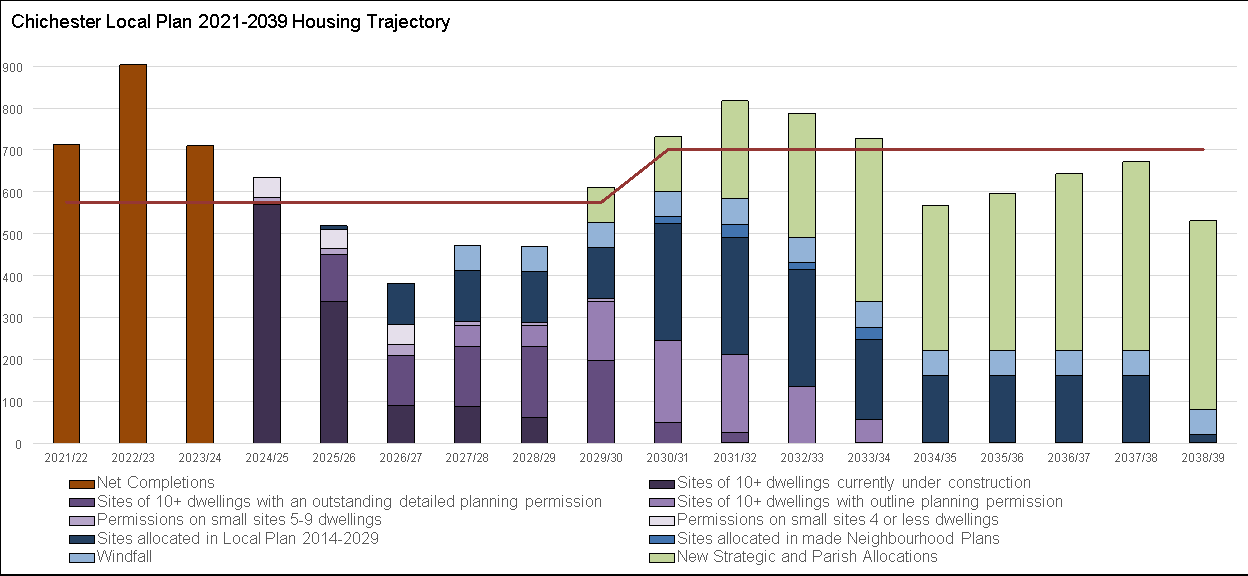
Appendix E: Housing Trajectory
|
Local Plan Housing Delivery & Phasing |
||||||||||||||||||||||||||
| Year of adoption | ||||||||||||||||||||||||||
|
Year 1 |
Year 2 |
Year 3 |
Year 4 |
Year 5 |
Year 6 |
Year 7 |
Year 8 |
Year 9 |
Year 10 |
Year 11 |
Year 12 |
Year 13 |
Year 14 |
|||||||||||||
|
2021/22 |
2022/23 |
2023/24 |
2024/25 |
2025/26 |
2026/27 |
2027/28 |
2028/29 |
2029/30 |
2030/31 |
2031/32 |
2032/33 |
2033/34 |
2034/35 |
2035/36 |
2036/37 |
2037/38 |
2038/39 |
|||||||||
|
Annual net housing requirement (575 21/22 - 29/30) (701 30/31 - 38/39) |
575 |
575 |
575 |
575 |
575 |
575 |
575 |
575 |
575 |
701 |
701 |
701 |
701 |
701 |
701 |
701 |
701 |
701 |
11484 |
|||||||
|
Cumulative net housing requirement |
575 |
1150 |
1725 |
2300 |
2875 |
3450 |
4025 |
4600 |
5175 |
5876 |
6577 |
7278 |
7979 |
8680 |
9381 |
10082 |
10783 |
11484 |
||||||||
|
Net Completions |
712 |
904 |
710 |
634* |
||||||||||||||||||||||
|
Cumulative net completions |
712 |
1616 |
2326 |
2960 |
||||||||||||||||||||||
|
Completions above/below housing requirement |
137 |
466 |
601 |
660 |
660 |
|||||||||||||||||||||
|
*estimated using expected build out rates of sites under construction |
||||||||||||||||||||||||||
|
Projected Housing Supply |
2025-30 |
2030-39 |
2025-39 |
|||||||||||||||||||||||
|
Sites of 10+ dwellings currently under construction |
569 |
339 |
89 |
87 |
62 |
0 |
0 |
1 |
0 |
1 |
1 |
1 |
1 |
1 |
1 |
577 |
7 |
584 |
||||||||
| Comprising: |
Parish |
Planning Ref |
Date Permitted |
Plan Sub-Area |
||||||||||||||||||||||
| Land On The North Side Of, Shopwhyke Road, Shopwhyke |
Oving |
11/05283/OUT, 15/03720/OUT, 14/02826/REM, 15/03964/REM, 19/01234/REM, 19/01235/REM, 19/01984/REM, 19/01983/REM, 21/01625/REM, 22/02344/REM, 23/01313/REM |
Outline (09/08/13) Outline (18/11/16) REM (09/01/15) REM (21/06/16) REM (03/03/20) REM (04/03/20) REM (19/03/20) REM (19/03/20) REM (20/08/21) REM (07/12/22) REM (16/05/24) |
East-West Corridor |
32 |
0 |
0 |
0 |
0 |
0 |
0 |
0 |
0 |
0 |
0 |
0 |
0 |
0 |
0 |
0 |
0 |
0 |
||||
| Graylingwell (inc Kingsmead Avenue) |
Chichester |
08/03533/OUT, 10/05597/OUT, 14/01018/OUT 10/02926/REM, 13/00907/REM, 13/00837/REM, 15/02506/REM, 16/02253/FUL, 16/02248/FUL, 18/01623/REM, 20/02905/REM |
Outline (19/08/09) Outline (28/11/12) REM (12/11/10) REM (04/07/13) REM (14/07/13) REM (08/01/16) Full (30/09/16) Full (26/10/16) REM (06/12/18) REM (06/05/21) |
East-West Corridor |
40 |
40 |
40 |
40 |
23 |
0 |
0 |
0 |
0 |
0 |
0 |
0 |
0 |
0 |
0 |
143 |
0 |
143 |
||||
| Land West Of Centurion Way And West Of Old Broyle Road |
Chichester |
14/04301/OUT, 18/01587/REM, 19/01134/REM, 20/02473/REM, 20/01046/REM, 19/03146/REM, 19/02819/REM, 19/02626/REM, 19/01531/REM, 20/03166/REM, 20/03108/REM, 21/00460/REM, 19/03122/REM, 21/00461/REM, 21/00460/REM, |
Outline (11/04/18) REM (05/12/18) REM (04/10/19) REM (05/03/21) REM (11/09/20) REM (04/06/20) REM (14/05/20) REM (07/05/20) REM (14/11/19) REM (06/05/21) REM (08/04/21) REM (03/03/22) REM (05/11/20) REM (05/11/21) REM (03/03/22) |
East-West Corridor |
143 |
19 |
0 |
0 |
0 |
0 |
0 |
0 |
0 |
0 |
0 |
0 |
0 |
0 |
0 |
19 |
0 |
19 |
||||
| Land East Of Manor Road Manor Road |
Selsey |
19/00321/FUL 22/02236/REM |
Full (09/12/2019) |
Manhood Peninsula |
62 |
34 |
0 |
0 |
0 |
0 |
0 |
0 |
0 |
0 |
0 |
0 |
0 |
0 |
0 |
34 |
0 |
34 |
||||
| Land North East of Graylingwell Park (Phase 2 Westhampnett/NE Chichester SDL) |
Chichester |
16/03791/OUT 18/01911/FUL (access) 19/03191/REM |
Outline (08/11/18) REM (01/07/21) |
East-West Corridor |
45 |
40 |
0 |
0 |
0 |
0 |
0 |
0 |
0 |
0 |
0 |
0 |
0 |
0 |
0 |
40 |
0 |
40 |
||||
| Land On The East Side Of Plaistow Road |
Kirdford |
15/03367/FUL 19/00086/FUL |
Full (22/11/18) Full (30/11/19) |
Plan Area (North) |
20 |
16 |
0 |
0 |
0 |
0 |
0 |
0 |
0 |
0 |
0 |
0 |
0 |
0 |
0 |
16 |
0 |
16 |
||||
| Former Portfield Quarry And Uma House Shopwhyke Road |
Chichester |
19/02030/FUL |
Full (12/06/20) |
East-West Corridor |
32 |
0 |
0 |
0 |
0 |
0 |
0 |
0 |
0 |
0 |
0 |
0 |
0 |
0 |
0 |
0 |
0 |
0 |
||||
| Land Adjoining A27 Scant Road West Hambrook** |
Chidham & Hambrook |
20/01826/FUL |
Full (04/11/21) |
East-West Corridor |
40 |
29 |
0 |
0 |
0 |
0 |
0 |
0 |
0 |
0 |
0 |
0 |
0 |
0 |
0 |
29 |
0 |
29 |
||||
| The Yews, City Fields Way |
Tangmere |
18/03143/FUL |
Full (24/07/19) |
East-West Corridor |
1 |
0 |
0 |
0 |
0 |
0 |
0 |
0 |
0 |
0 |
0 |
0 |
0 |
0 |
0 |
0 |
0 |
0 |
||||
|
Woodfield House Tangmere Road |
Tangmere |
23/00307/PA3MA |
PN (24/03/23) |
East-West Corridor |
18 |
0 |
0 |
0 |
0 |
0 |
0 |
0 |
0 |
0 |
0 |
0 |
0 |
0 |
0 |
0 |
0 |
0 |
||||
|
Land North of Cooks Lane |
Southbourne |
18/03145/OUT 22/00157/REM |
Outline (02/03/20) REM (31/08/22) |
East-West Corridor |
35 |
43 |
43 |
43 |
35 |
0 |
0 |
0 |
0 |
0 |
0 |
0 |
0 |
0 |
0 |
164 |
0 |
164 |
||||
| Land West Of Guildford Road** |
Loxwood |
20/01977/FUL |
Full (16/08/23) |
Plan Area (North) |
4 |
23 |
0 |
0 |
0 |
0 |
0 |
0 |
0 |
0 |
0 |
0 |
0 |
0 |
0 |
23 |
0 |
23 |
||||
|
Warrendell, off Plainwood Close |
Chichester |
98/02043/OUT 20/01164/REM |
Outline (29/11/18) REM (16/07/21) |
East-West Corridor |
4 |
3 |
6 |
4 |
4 |
0 |
0 |
0 |
0 |
0 |
0 |
0 |
0 |
0 |
0 |
17 |
0 |
17 |
||||
|
Former Lowlands Nursery Lagness Road** |
North Mundham |
20/01686/FUL |
Full (11/08/21) |
Manhood Peninsula |
10 |
29 |
0 |
0 |
0 |
0 |
0 |
0 |
0 |
0 |
0 |
0 |
0 |
0 |
0 |
29 |
0 |
29 |
||||
| Greenways Nursery, Kirdford Road |
Wisborough Green |
13/00744/FUL |
Full (30/12/14) |
Plan Area (North) |
0 |
0 |
0 |
0 |
0 |
0 |
0 |
1 |
0 |
1 |
1 |
1 |
1 |
1 |
1 |
0 |
7 |
7 |
||||
| Park Farm Park Lane |
Selsey |
20/00085/FUL |
Full (20/05/20) |
Manhood Peninsula |
38 |
0 |
0 |
0 |
0 |
0 |
0 |
0 |
0 |
0 |
0 |
0 |
0 |
0 |
0 |
0 |
0 |
0 |
||||
| Phase 3A (Shopwhyke Care Site) Land On The North Side Of Shopwhyke Road |
Oving |
21/00258/FUL |
Full (09/07/21) |
East-West Corridor |
45 |
0 |
0 |
0 |
0 |
0 |
0 |
0 |
0 |
0 |
0 |
0 |
0 |
0 |
0 |
0 |
0 |
0 |
||||
|
Graylingwell Hospital |
Chichester |
14/01018/OUT 22/01501/REM |
Outline (21/03/18) REM (30/05/23) |
East-West Corridor |
0 |
63 |
0 |
0 |
0 |
0 |
0 |
0 |
0 |
0 |
0 |
0 |
0 |
0 |
0 |
63 |
0 |
63 |
||||
|
Sites of 10+ dwellings with an outstanding detailed planning permission |
112 |
121 |
144 |
169 |
196 |
50 |
25 |
0 |
0 |
0 |
0 |
0 |
0 |
0 |
742 |
75 |
817 |
|||||||||
|
Comprising: |
Parish |
Planning Ref |
Date Permitted |
Plan Sub-Area |
||||||||||||||||||||||
| Land South Of Lowlands** |
North Mundham |
20/02989/FUL |
Full (01/12/23) |
Manhood Peninsula |
29 |
29 |
8 |
0 |
0 |
0 |
0 |
0 |
0 |
0 |
0 |
0 |
0 |
0 |
66 |
0 |
66 |
|||||
| Land North Of 30 To 56 Mill Road** |
Westbourne |
20/01061/FUL |
Full (02/02/23) |
East-West Corridor |
12 |
0 |
0 |
0 |
0 |
0 |
0 |
0 |
0 |
0 |
0 |
0 |
0 |
0 |
12 |
0 |
12 |
|||||
| Chas Wood Nurseries Main Road** |
Chidham and Hambrook |
20/01854/OUT 23/01164/REM |
Outline (17/10/22) REM (14/02/24) |
East-West Corridor |
26 |
0 |
0 |
0 |
0 |
0 |
0 |
0 |
0 |
0 |
0 |
0 |
0 |
0 |
26 |
0 |
26 |
|||||
| G & R Harris, Main Road** |
Southbourne |
22/01283/FULEIA |
Full (18/09/23) |
East-West Corridor |
20 |
40 |
43 |
0 |
0 |
0 |
0 |
0 |
0 |
0 |
0 |
0 |
0 |
0 |
103 |
0 |
103 |
|||||
| Highgrove Farm** |
Bosham |
21/00571/FUL Site Allocation DPD Policy BO1 |
Full (09/11/23) |
East-West Corridor |
25 |
50 |
50 |
50 |
50 |
50 |
25 |
0 |
0 |
0 |
0 |
0 |
0 |
0 |
225 |
75 |
300 |
|||||
| Field North West Of The Saltings, Crooked Lane |
Birdham |
BI/13/01391/FUL & BI/16/01809/FUL |
Full (29/11/13) Full (14/10/16) |
Manhood Peninsula |
0 |
0 |
0 |
0 |
15 |
0 |
0 |
0 |
0 |
0 |
0 |
0 |
0 |
0 |
15 |
0 |
15 |
|||||
| Land To The West Of Church Road Church Road |
West Wittering |
20/02491/OUT 24/00266/REM |
Outline (22/04/22) REM (09/10/24) |
Manhood Peninsula |
0 |
0 |
12 |
48 |
10 |
0 |
0 |
0 |
0 |
0 |
0 |
0 |
0 |
0 |
70 |
0 |
70 |
|||||
| Land south of Clappers Lane |
Earnley |
20/03125/OUT 23/02916/REM |
Outline (16/08/22) REM (15/08/24) |
Manhood Peninsula |
0 |
2 |
31 |
40 |
27 |
0 |
0 |
0 |
0 |
0 |
0 |
0 |
0 |
0 |
100 |
0 |
100 |
|||||
| Land at Flat Farm, Broad Road |
Chidham & Hambrook |
20/03378/OUT 23/02730/REM |
Outline (31/08/23) REM (11/07/24) |
East-West Corridor |
0 |
0 |
0 |
15 |
15 |
0 |
0 |
0 |
0 |
0 |
0 |
0 |
0 |
0 |
30 |
0 |
30 |
|||||
| Russells Garden Centre |
Birdham |
23/00067/FUL |
Full (12/09/24) |
Manhood Peninsula |
0 |
0 |
0 |
0 |
14 |
0 |
0 |
0 |
0 |
0 |
0 |
0 |
0 |
0 |
14 |
0 |
14 |
|||||
| Land At The Junction Of Western Road Shopwhyke Lakes |
Oving |
23/02212/FUL |
Full (23/08/24) |
East-West Corridor |
0 |
0 |
0 |
0 |
55 |
0 |
0 |
0 |
0 |
0 |
0 |
0 |
0 |
0 |
55 |
0 |
55 |
|||||
| Land North West Of 56 Stane Street (Rohan Stables)** |
Boxgrove |
23/02169/FUL |
Full (09/12/24) |
East-West Corridor |
0 |
0 |
0 |
16 |
10 |
0 |
0 |
0 |
0 |
0 |
0 |
0 |
0 |
0 |
26 |
0 |
26 |
|||||
|
Sites of 10+ dwellings with outline planning permission |
0 |
0 |
50 |
50 |
142 |
194 |
185 |
135 |
54 |
0 |
0 |
0 |
0 |
0 |
242 |
568 |
810 |
|||||||||
| Comprising: |
Parish |
Planning Ref |
Date Permitted |
Plan Sub-Area |
||||||||||||||||||||||
| Land South Of Loxwood Farm Place High Street |
Loxwood |
20/01617/OUT |
Outline (15/10/20) |
Plan Area (North) |
0 |
0 |
0 |
0 |
0 |
18 |
6 |
0 |
0 |
0 |
0 |
0 |
0 |
0 |
0 |
24 |
24 |
|||||
| Land East Of Glenmore Business Park Longacres Way |
Oving |
21/00594/OUT |
Outline (21/01/22) |
East-West Corridor |
0 |
0 |
0 |
0 |
0 |
23 |
0 |
0 |
0 |
0 |
0 |
0 |
0 |
0 |
0 |
23 |
23 |
|||||
| Land Within The Westhampnett / North East Chichester Strategic Development Location (north Of Madgwick Lane) |
Westhampnett |
20/02824/OUT |
Outline (27/05/22) |
East-West Corridor |
0 |
0 |
50 |
50 |
65 |
0 |
0 |
0 |
0 |
0 |
0 |
0 |
0 |
0 |
165 |
0 |
165 |
|||||
| Earnley Concourse Clappers Lane |
Earnley |
19/02493/OUT |
Outline (30/05/22) |
Manhood Peninsula |
0 |
0 |
0 |
0 |
25 |
5 |
0 |
0 |
0 |
0 |
0 |
0 |
0 |
0 |
25 |
5 |
30 |
|||||
| Land Off Main Road |
Birdham |
21/01830/OUT |
Outline (09/02/24) |
Manhood Peninsula |
0 |
0 |
0 |
0 |
0 |
43 |
43 |
43 |
21 |
0 |
0 |
0 |
0 |
0 |
0 |
150 |
150 |
|||||
| Land East of Broad Road, Nutbourne** |
Chidham & Hambrook |
20/03320/OUTEIA |
Outline (29/08/23) |
East-West Corridor |
0 |
0 |
0 |
0 |
30 |
34 |
34 |
34 |
0 |
0 |
0 |
0 |
0 |
0 |
30 |
102 |
132 |
|||||
| Land West of Drift Lane** |
Chidham & Hambrook |
20/03321/OUTEIA |
Outline (29/08/23) |
East-West Corridor |
0 |
0 |
0 |
0 |
22 |
22 |
24 |
0 |
0 |
0 |
0 |
0 |
0 |
0 |
22 |
46 |
68 |
|||||
| Charmans Field |
North Mundham |
22/02191/OUT |
Outline (08/03/24) |
Manhood Peninsula |
0 |
0 |
0 |
0 |
0 |
29 |
29 |
29 |
7 |
0 |
0 |
0 |
0 |
0 |
0 |
94 |
94 |
|||||
| Four Acre Nursery Cooks Lane** |
Southbourne |
22/01903/OUT |
Outline (22/08/24) |
East-West Corridor |
0 |
0 |
0 |
0 |
0 |
20 |
20 |
0 |
0 |
0 |
0 |
0 |
0 |
0 |
0 |
40 |
40 |
|||||
| Land To The North Of Penny Lane Penny Lane Hermitage** |
Southbourne |
23/00024/OUT |
Outline (04/12/24) |
East-West Corridor |
0 |
0 |
0 |
0 |
0 |
0 |
29 |
29 |
26 |
0 |
0 |
0 |
0 |
0 |
0 |
84 |
84 |
|||||
|
Permissions on small sites 5-9 dwellings |
17 |
13 |
25 |
10 |
8 |
8 |
0 |
0 |
0 |
0 |
0 |
0 |
0 |
0 |
0 |
64 |
0 |
64 |
||||||||
| Comprising: |
Parish |
Planning Ref |
Date Permitted |
Plan Sub-Area |
||||||||||||||||||||||
| Elmsleigh 30 First Avenue |
Southbourne |
16/00407/FUL |
Full (25/05/16) |
East-West Corridor |
5 |
0 |
0 |
0 |
0 |
0 |
0 |
0 |
0 |
0 |
0 |
0 |
0 |
0 |
0 |
0 |
0 |
0 |
||||
| Land North West Of 139 Main Road** |
Southbourne |
20/02297/FUL |
Full (23/06/22) |
East-West Corridor |
8 |
0 |
0 |
0 |
0 |
0 |
0 |
0 |
0 |
0 |
0 |
0 |
0 |
0 |
0 |
0 |
0 |
0 |
||||
| Land south of Reedbridge Farm |
Hunston |
18/01320/FUL Site Allocation DPD Policy HN1 |
DPD Allocation Full (16/09/18) |
Manhood Peninsula |
3 |
0 |
0 |
0 |
0 |
0 |
0 |
0 |
0 |
0 |
0 |
0 |
0 |
0 |
0 |
0 |
0 |
0 |
||||
| 99 - 101 High Street |
Selsey |
22/02196/FUL |
Full (29/11/21) |
Manhood Peninsula |
0 |
5 |
0 |
0 |
0 |
0 |
0 |
0 |
0 |
0 |
0 |
0 |
0 |
0 |
0 |
5 |
0 |
5 |
||||
| Earnley Gardens Almodington Lane Almodington |
Earnley |
20/03289/FUL |
Full (11/02/22) |
Manhood Peninsula |
1 |
0 |
0 |
0 |
0 |
0 |
0 |
0 |
0 |
0 |
0 |
0 |
0 |
0 |
0 |
0 |
0 |
0 |
||||
| 1-4 Claytons Corner |
Birdham |
24/00061/FUL |
Full (21/03/24) |
Manhood Peninsula |
0 |
-4 |
0 |
5 |
0 |
0 |
0 |
0 |
0 |
0 |
0 |
0 |
0 |
0 |
0 |
1 |
0 |
1 |
||||
| Caravan And Camping Site Orchard Farm Drift Lane |
Bosham |
21/02303/OUT |
Outline (20/11/23) |
East-West Corridor |
0 |
0 |
4 |
5 |
0 |
0 |
0 |
0 |
0 |
0 |
0 |
0 |
0 |
0 |
0 |
9 |
0 |
9 |
||||
| Land South West Of Willets Way Willetts Way** |
Loxwood |
23/01104/FUL |
Full (15/08/23) |
Plan Area (North) |
0 |
5 |
0 |
0 |
0 |
0 |
0 |
0 |
0 |
0 |
0 |
0 |
0 |
0 |
0 |
5 |
0 |
5 |
||||
| Land West of Monks Hill |
Westbourne |
22/00209/FUL Westbourne Neighbourhood Plan Policy SS1 |
Full (18/10/23) |
East-West Corridor |
0 |
4 |
5 |
0 |
0 |
0 |
0 |
0 |
0 |
0 |
0 |
0 |
0 |
0 |
0 |
9 |
0 |
9 |
||||
| Land South Of West View Cottages South Lane** |
Southbourne |
22/00593/FUL |
Full (28/03/24) |
East-West Corridor |
0 |
3 |
4 |
0 |
0 |
0 |
0 |
0 |
0 |
0 |
0 |
0 |
0 |
0 |
0 |
7 |
0 |
7 |
||||
| Land at Stable Field** |
Wisborough Green |
22/00618/FUL |
Full (17/04/24) |
Plan Area (North) |
0 |
0 |
0 |
0 |
0 |
8 |
0 |
0 |
0 |
0 |
0 |
0 |
0 |
0 |
0 |
8 |
0 |
8 |
||||
| The Bill House Rest Home 98 Grafton Road |
Selsey |
24/01100/FUL |
Full (07/08/24) |
Manhood Peninsula |
0 |
0 |
0 |
0 |
8 |
0 |
0 |
0 |
0 |
0 |
0 |
0 |
0 |
0 |
0 |
8 |
0 |
8 |
||||
| Glenmar House Brandy Hole Lane** |
Chichester |
19/02241/FUL |
Full (17/01/25) |
East-West Corridor |
0 |
0 |
6 |
0 |
0 |
0 |
0 |
0 |
0 |
0 |
0 |
0 |
0 |
0 |
0 |
6 |
0 |
6 |
||||
| 38 South Street** |
Chichester |
24/01029/LBC |
Full (22/01/25) |
East-West Corridor |
0 |
0 |
6 |
0 |
0 |
0 |
0 |
0 |
0 |
0 |
0 |
0 |
0 |
0 |
0 |
6 |
0 |
6 |
||||
|
Permissions on small sites 4 or less dwellings |
48 |
47 |
47 |
0 |
0 |
0 |
0 |
0 |
0 |
0 |
0 |
0 |
0 |
0 |
0 |
94 |
0 |
94 |
||||||||
|
Sites allocated in Local Plan 2014-2029 |
8 |
100 |
120 |
120 |
120 |
280 |
280 |
280 |
192 |
160 |
160 |
160 |
160 |
20 |
468 |
1692 |
2160 |
|||||||||
| Comprising: |
Parish |
Planning Ref |
Date Permitted |
Plan Sub-Area |
||||||||||||||||||||||
| West of Chichester SDL (Phase 2) |
Chichester |
Chichester Local Plan Policy 15 22/01485/OUTEIA - |
Outline (subject to s106) 10/01/24 |
East-West Corridor |
8 |
100 |
120 |
120 |
120 |
120 |
120 |
120 |
22 |
0 |
0 |
0 |
0 |
0 |
468 |
382 |
850 |
|||||
| Tangmere SDL |
Tangmere |
Chichester Local Plan Policy 18 20/02893/OUT |
Outline (subject to s106) 16/08/23 |
East-West Corridor |
0 |
0 |
0 |
0 |
0 |
160 |
160 |
160 |
160 |
160 |
160 |
160 |
160 |
20 |
0 |
1300 |
1300 |
|||||
| Land north of Little Springfield Farm, Ifold |
Plaistow & Ifold |
Site Allocation DPD Policy PL1 |
Plan Area (North) |
0 |
0 |
0 |
0 |
0 |
0 |
0 |
0 |
10 |
0 |
0 |
0 |
0 |
0 |
0 |
10 |
10 |
||||||
|
Sites allocated in made Neighbourhood Plans |
0 |
0 |
0 |
0 |
0 |
17 |
32 |
15 |
30 |
0 |
0 |
0 |
0 |
0 |
0 |
94 |
94 |
|||||||||
| Comprising: |
Parish |
Planning Ref |
Date Permitted |
Plan Sub-Area |
||||||||||||||||||||||
| Land at Farm Close |
Loxwood |
Loxwood Neighbourhood Plan Policy 4 |
Plan Area (North) |
0 |
0 |
0 |
0 |
0 |
17 |
0 |
0 |
0 |
0 |
0 |
0 |
0 |
0 |
0 |
17 |
17 |
||||||
| Tangmere Academy |
Tangmere |
Tangmere Neighbourhood Plan Policy 4 |
East-West Corridor |
0 |
0 |
0 |
0 |
0 |
0 |
0 |
0 |
15 |
0 |
0 |
0 |
0 |
0 |
0 |
15 |
15 |
||||||
| Land to the West of Malcolm Road |
Tangmere |
Tangmere Neighbourhood Plan Policy 7 |
East-West Corridor |
0 |
0 |
0 |
0 |
0 |
0 |
12 |
0 |
0 |
0 |
0 |
0 |
0 |
0 |
0 |
12 |
12 |
||||||
| Clark's Yard, Billingshurst Road |
Wisborough Green |
Wisborough Green Neighbourhood Plan Policy SS3 |
Plan Area (North) |
0 |
0 |
0 |
0 |
0 |
0 |
11 |
0 |
0 |
0 |
0 |
0 |
0 |
0 |
0 |
11 |
11 |
||||||
| Land at the Roman Palace |
Fishbourne |
Fishbourne Neighbourhood Plan Policy SD2 |
East-West Corridor |
0 |
0 |
0 |
0 |
0 |
0 |
0 |
0 |
15 |
0 |
0 |
0 |
0 |
0 |
0 |
15 |
15 |
||||||
| Land at Townfield |
Kirdford |
Kirdford Neighbourhood Plan Policy KSS2a |
Plan Area (North) |
0 |
0 |
0 |
0 |
0 |
0 |
0 |
6 |
0 |
0 |
0 |
0 |
0 |
0 |
0 |
6 |
6 |
||||||
| Land at Cornwood and/or School Court |
Kirdford |
Kirdford Neighbourhood Plan Policy KSS5 |
Plan Area (North) |
0 |
0 |
0 |
0 |
0 |
0 |
0 |
9 |
0 |
0 |
0 |
0 |
0 |
0 |
0 |
9 |
9 |
||||||
| Land adjacent to Chantry Hall, Foxbury Lane |
Westbourne |
Westbourne Neighbourhood Plan Policy SS3 |
East-West Corridor |
0 |
0 |
0 |
0 |
0 |
0 |
6 |
0 |
0 |
0 |
0 |
0 |
0 |
0 |
0 |
6 |
6 |
||||||
| Land at The Old Granary |
Boxgrove |
Boxgrove Neighbourhood Plan Policy H5 |
East-West Corridor |
0 |
0 |
0 |
0 |
0 |
0 |
3 |
0 |
0 |
0 |
0 |
0 |
0 |
0 |
0 |
3 |
3 |
||||||
|
Windfall |
0 |
0 |
60 |
60 |
60 |
60 |
60 |
60 |
60 |
60 |
60 |
60 |
60 |
60 |
180 |
540 |
720 |
|||||||||
|
* Sites highlighted and with two asterisks (**) are counted towards housing requirements as set out Policies H2 and H3. |
2025-30 |
2030-39 |
2025-39 |
No. of Dwellings in Policy |
||||||||||||||||||||||
|
New Strategic and Parish Allocations |
0 |
0 |
0 |
0 |
85 |
130 |
234 |
297 |
391 |
346 |
375 |
422 |
451 |
450 |
85 |
3096 |
3181 |
4118 |
||||||||
| Comprising: |
Parish |
Policy Ref |
Plan Sub-Area |
Remaining Figure to Allocate* | ||||||||||||||||||||||
|
Chichester City |
Chichester |
Policy A2 |
East-West Corridor |
0 |
0 |
0 |
0 |
0 |
12 |
24 |
24 |
24 |
24 |
35 |
35 |
35 |
35 |
0 |
248 |
248 |
270 |
|||||
|
Southern Gateway |
Chichester |
Policy A4 & A5 |
East-West Corridor |
0 |
0 |
0 |
0 |
0 |
0 |
0 |
42 |
28 |
0 |
0 |
47 |
47 |
16 |
0 |
180 |
180 |
180 |
|||||
|
East of Chichester |
Oving |
Policy A8 |
East-West Corridor |
0 |
0 |
0 |
0 |
45 |
60 |
60 |
80 |
80 |
80 |
80 |
65 |
65 |
65 |
45 |
635 |
680 |
680 |
|||||
|
Maudlin Farm |
Westhampnett |
Policy A10 |
East-West Corridor |
0 |
0 |
0 |
0 |
40 |
50 |
50 |
50 |
50 |
25 |
0 |
0 |
0 |
0 |
40 |
225 |
265 |
265 |
|||||
|
Highgrove Farm Bosham |
Bosham |
Policy A11 |
East-West Corridor |
0 |
0 |
0 |
0 |
0 |
0 |
0 |
0 |
0 |
0 |
0 |
0 |
0 |
0 |
0 |
0 |
0 |
245 |
|||||
|
Chidham & Hambrook |
Chidham & Hambrook |
Policy A12 |
East-West Corridor |
0 |
0 |
0 |
0 |
0 |
0 |
0 |
0 |
0 |
0 |
0 |
0 |
0 |
0 |
0 |
0 |
0 |
300 |
|||||
| Southbourne |
Southbourne |
Policy A13 |
East-West Corridor |
0 |
0 |
0 |
0 |
0 |
8 |
100 |
100 |
100 |
100 |
100 |
100 |
100 |
100 |
0 |
808 |
808 |
1050 |
|||||
| Loxwood |
Loxwood |
Policy A15 |
Plan Area (North) |
0 |
0 |
0 |
0 |
0 |
0 |
0 |
0 |
0 |
0 |
38 |
50 |
50 |
50 |
0 |
188 |
188 |
220 |
|||||
| Boxgrove |
Boxgrove |
Policy H3 |
East-West Corridor |
0 |
0 |
0 |
0 |
0 |
0 |
0 |
0 |
0 |
0 |
0 |
0 |
7 |
17 |
0 |
24 |
24 |
50 |
|||||
| Westbourne |
Westbourne |
Policy H3 |
East-West Corridor |
0 |
0 |
0 |
0 |
0 |
0 |
0 |
0 |
0 |
0 |
0 |
0 |
1 |
17 |
0 |
18 |
18 |
30 |
|||||
| Fishbourne |
Fishbourne |
Policy H3 |
East-West Corridor |
0 |
0 |
0 |
0 |
0 |
0 |
0 |
0 |
0 |
0 |
0 |
0 |
13 |
17 |
0 |
30 |
30 |
30 |
|||||
|
North Mundham |
North Mundham |
Policy H3 |
Manhood Peninsula |
0 |
0 |
0 |
0 |
0 |
0 |
0 |
0 |
0 |
0 |
0 |
0 |
0 |
0 |
0 |
0 |
0 |
50 |
|||||
| Kirdford |
Kirdford |
Policy H3 |
Plan Area (North) |
0 |
0 |
0 |
0 |
0 |
0 |
0 |
0 |
0 |
6 |
11 |
11 |
11 |
11 |
0 |
50 |
50 |
50 |
|||||
|
Plaistow and Ifold |
Plaistow and Ifold |
Policy H3 |
Plan Area (North) |
0 |
0 |
0 |
0 |
0 |
0 |
0 |
0 |
0 |
0 |
0 |
3 |
11 |
11 |
0 |
25 |
25 |
25 |
|||||
|
Wisborough Green |
Wisborough Green |
Policy H3 |
Plan Area (North) |
0 |
0 |
0 |
0 |
0 |
0 |
0 |
1 |
11 |
11 |
11 |
11 |
11 |
11 |
0 |
67 |
67 |
75 |
|||||
| Site Allocation DPD - to deliver residual dwellings as required by Policy H1 |
Policy H1 |
0 |
0 |
0 |
0 |
0 |
0 |
0 |
0 |
98 |
100 |
100 |
100 |
100 |
100 |
0 |
598 |
598 |
598 |
|||||||
|
Total Projected Housing Supply |
634 |
519 |
382 |
471 |
469 |
611 |
731 |
817 |
787 |
728 |
567 |
596 |
643 |
672 |
531 |
2452 |
6072 |
8524 |
||||||||
|
Completions above housing requirement (average over 5 year supply period) |
120.2 |
132 |
132 |
132 |
132 |
132 |
||||||||||||||||||||
|
Total Housing Supply (including completions above housing requirement) |
754 |
651 |
514 |
603 |
601 |
743 |
731 |
817 |
787 |
728 |
567 |
596 |
643 |
672 |
531 |
|||||||||||
|
Total Supply 2021-2039 |
11484 |
|||||||||||||||||||||||||
|
Projected Five Year Supply Position |
2024/25 |
2025/26 |
2026/27 |
2027/28 |
2028/29 |
2029/30 |
2030/31 |
2031/32 |
2032/33 |
2033/34 |
2034/35 |
|||||||||||||||
|
Projected five year housing supply |
3123 |
3112 |
3192 |
3495 |
3679 |
3806 |
3630 |
3495 |
3321 |
3206 |
3009 |
|||||||||||||||
|
Adjusted five year housing requirement (+5% buffer) |
3019 |
3019 |
3151 |
3283 |
3416 |
3548 |
3680 |
3680 |
3680 |
3680 |
3680 |
|||||||||||||||
|
Projected years housing supply |
5.17 |
5.15 |
5.06 |
5.32 |
5.39 |
5.36 |
4.93 |
4.75 |
4.51 |
4.36 |
4.09 |
|||||||||||||||
Graph
Appendix F: Monitoring Framework
F.1 This Appendix shows how the implementation of policies in the Local Plan will be monitored.
F.2 The purpose of monitoring is to assess whether the policies of the Local Plan are achieving the objectives and intended policy outcomes, whether they are having any unintended consequences and whether they require a review.
F.3 In accordance with the transitional arrangements set out in the NPPF (2024) paragraph 236, the council is required to immediately commence a review of the Local Plan under the new plan-making system.
F.4 Monitoring proposed by the Sustainability Appraisals to check the predicted effects of the Local Plan policies has informed the monitoring framework.
F.5 The monitoring framework is set out in relation to the Local Plan chapters with those policies with identified targets listed together with their relevant monitoring indicators.
F.6 The effectiveness of policies is assessed, where possible, against measurable targets. However, some policies aim to deliver a qualitative rather than a quantitative outcome. In such instances, it is appropriate to monitor whether the policy is delivering the intended trend or direction of travel. For some policies, measurable targets may be set through subsequent Development Plan Documents or Supplementary Planning Documents.
F.7 The indicators have been selected based on their appropriateness for gauging the effectiveness of the Local Plan policies. The choice of specific indicators is dependent upon the availability of data and in this respect, it is possible these could change over time. The specific indicators used will therefore be reviewed on a regular basis and where the availability of data changes, then some indicators may need to be removed whilst others could potentially be added.
F.8 The indicators will be monitored annually through the Authority's Monitoring Report (AMR). The AMR will contain information on the implementation of the Local Plan policies and an assessment of their effectiveness whilst indicating whether any changes need to be considered if a policy is not working or if the targets are not being met. The AMR is published on the council's website.
|
Chapter/policies |
Target to be achieved |
Delivery |
Monitoring indicators |
Responsible agency/partner |
|
Chapter 3 Spatial Strategy |
||||
|
Policies: S1 Spatial Development Strategy; S2 Settlement Hierarchy; |
Distribution of development in line with development strategy |
Local Plan Neighbourhood Plans Site Allocation DPD Development Management process |
Distribution throughout plan area of new homes and all other built development split by settlement hierarchy |
Chichester DC Parish Councils Developers and Landowners Infrastructure providers |
|
Delivery of local community facilities, small-scale employment, tourism and leisure |
Distribution of completed community development, employment, tourism and leisure/recreation proposals throughout plan area |
|||
|
Chapter 4 Climate Change and the Natural Environment |
||||
|
Policies: NE2 Natural Landscape; NE3 Landscape Gaps between Settlements; NE4 Strategic Wildlife Corridors; NE5 Biodiversity and Biodiversity Net Gain; NE6 Chichester's Internationally and European Designated Habitats; NE7 The Mens SAC and Air Quality; NE8 Development and Disturbance of Birds in Chichester and Langstone Harbours, Pagham Harbour, Solent and Dorset Coast SPAs and Medmerry Compensatory Habitat; NE11 Development in the Countryside; NE12 The Coast; NE16 Flood Risk and Water Management; NE17 Water Management and Water Quality; NE18 Water Neutrality; NE19 Source Protection Zones; NE20 Nutrient Neutrality; NE21 Pollution |
Protect and enhance the natural landscape; strategic wildlife corridors; biodiversity habitats and coastal areas |
Local Plan Neighbourhood Plans Site Allocations DPD Development Management process Biodiversity Action Plans Sussex North Water NeutralityMitigation Strategy |
Monitor number of permissions granted: within 5.6 km 'Zone of Influence' within strategic wildlife corridors; within landscape gaps or between settlements; outside settlement boundaries; for marine development; contrary to Environment Agency advice on flood risk and water quality issues; contrary to LLFA advice on flood risk issues; for air quality sensitive development granted within AQMAs; near designated Dark Sky Discovery Sites/SDNP International Dark Sky Reserve |
Chichester DC Parish Councils Developers and Landowners Sussex Biodiversity Record Centre West Sussex CC Environment Agency Joint affected LPAs across Sussex North Water Resource Zone Natural England Chichester DC and, if required, Horsham DC |
|
Mitigate/avoid effect on SPAs of all net increases in residential development within Zone of Influence Achieve zero permissions granted contrary to Local Lead Flood Authority advice on flood risk issues and Environment Agency advice on flood risk and water quality issues |
||||
|
To avoid an in-combination effect of ammonia deposition on The Mens SAC for beech woodland supporting lichens and bryophytes above the 1% critical level threshold from development |
||||
|
Automatic Number Plate Recognition (ANPR) monitoring on the A272 to determine the uptake of ultra-low emission vehicles over time (within 5 years of adoption) |
||||
|
Prevent coalescence of built-up areas and maintain separate identity of settlements; restrict development outside of settlement boundaries to countryside uses |
Monitor decisions on planning applications refused and appeals upheld on landscape considerations; number of EIA Application approvals within AONB; areas of best and most versatile agricultural land taken out of agricultural use for major developments |
|||
|
Protect water quality and water supply within the Chichester Local Plan area; achieve water neutrality within Sussex North Water Resource Zone |
Daily domestic water use; number of permissions granted within Sussex North Water Resource Zone; number of applications refused for failing to demonstrate water neutrality; number of permissions granted within Source Protection Zones 1 and 1c |
|||
|
Percentage of SSSI land in favourable condition including percentage in coastal area; changes in areas of biodiversity importance and percentage of water bodies assessed as good ecological status / good chemical status |
||||
|
Ensure no net increase and where possible, reduce nutrients discharged into Chichester Harbour |
||||
|
Protect/improve amenities and the environment by mitigating possible pollution impacts of development |
Annual average NO2 data from selected sites in the District; Carbon dioxide emissions – total by sector and per capita |
|||
|
Chapter 5 Housing |
||||
|
Policies: H1 Meeting Housing Needs; H2 Strategic Locations/ Allocations H3 Non-Strategic Parish Housing Requirements; H4 Affordable Housing; H6 Custom and/or Self Build Homes H11 Meeting Gypsies, Travellers and Travelling Showpeoples' Needs |
Delivery of 11,484 net additional homes between 2021 and 2039 (638 dwellings per year) stepped as follows: 575 dpa for the years 2021/22 to 2029/30; 701 dpa for the years 2030/31 to 2038/39;meeting parish housing requirement If previous years cumulative housing delivery exceeds past cumulative housing requirement as set out in Policy H1, any oversupply will be factored into the most recent 5 Year Housing Land Supply assessment |
Local Plan Neighbourhood Plans Site Allocations DPD Development Management process |
New homes built each year (net) split by strategic sites, parish housing and windfall |
Chichester DC/ West Sussex CC/Parish Councils Developers and Landowners/ Registered Social Landlords Infrastructure providers Homes England and Regulator of Social Housing , Gypsy, Traveller and Travelling Showpeople's organisations |
|
Affordable Housing: North of the Plan Area – 40% on greenfield sites, 30% on previously developed land; South of the Plan Area – 30% on greenfield sites, 20% on previously developed land |
Affordable homes built each year by type and as a percentage of all homes built |
|||
|
130 net pitches for Gypsies and Travellers and 40 net plots for Travelling Showpeople over the plan period Self/Custom Build: provide for 112 suitable serviced plots over the plan period |
Net additional GTTS pitches and plots granted permission each year |
|||
|
Net additional self/custom build plots provided each year |
||||
|
Chapter 6 Placemaking, Health and Wellbeing |
||||
|
Policies: P1 Design Principles; P9 The Historic Environment P14 Green Infrastructure; P16 Health and Wellbeing; P17 New and Existing Local and Community Facilities including Local Shops |
Promote high quality design principles for new development that enhance the area |
Local Plan Neighbourhood Plans Site Allocations DPD Infrastructure Delivery Plan Development Management process Design and Access Statements Character Appraisals for Conservation Areas |
Monitoring decisions on planning applications refused and appeals upheld on design grounds |
Chichester DC West Sussex CC Parish Councils Developers and Landowners Infrastructure providers Historic England Sussex Wildlife Trust |
|
Improve and promote healthy communities |
Percentage of adults who participate in different levels of exercise per week; Waste collected/ recycled per household |
|||
|
Reinforce and enhance role of green infrastructure |
Monitoring: delivery of green infrastructure and amenity open space provision; strategic development schemes providing long term agreement to maintain and enhance green infrastructure network in vicinity of site |
|||
|
Conserve or enhance heritage assets within the plan area |
Monitoring planning permissions and appeals affecting heritage assets at risk |
|||
|
Number of designated heritage assets and number and proportion of heritage assets at risk; Current conservation area appraisals |
||||
|
Chapter 7 Employment and the Economy |
||||
|
Policies: E1 Meeting Employment Needs; E3 Addressing Horticultural Needs E5 Retail Strategy and New Development; E7 Local Centres; |
Delivery of 115,000 sq.m net additional floorspace in E(g), B2 and B8 Use Classes between 2021 and 2039, in line with HEDNA |
Local Plan Site Allocation DPD Neighbourhood Plans Development Management process Economic Development Strategy |
Employment floor space completions, commitments, losses (including vacancy rates), net position by use class across Local Plan area and on allocated employment sites |
Chichester DC West Sussex CC Parish and Town Councils Developers, Landowners and Local Businesses/ Organisations Coast to Capital LEP Chichester BID West Sussex Growers Association |
|
Percentage change in the number of VAT registered businesses; Percentage of employees in different sectors |
||||
|
For the period to 2035 provision will be made for 6600 sq.m (gross) of comparison and convenience goods retail floorspace and food/beverage uses across the Local Plan area, primarily through the re-occupation of vacant floorspace, as well as limited new development within strategic housing sites |
Monitoring of retail and food/ beverage floor space, gained or lost (including vacancy rates) in Chichester city and the Local Plan area |
|||
|
Maintain vitality and viability of local centres |
Monitoring of commercial, leisure and retail development gained or lost (including vacancy rates) in local centres |
|||
|
Delivery of approximately 204 hectares land within Local Plan area (67 hectares within HDAs) for horticultural development |
Amount of horticultural development permitted by type and location inside and outside of HDAs including any losses; Amount of land remaining undeveloped in HDAs |
|||
|
Chapter 8 Transport and Accessibility |
||||
|
Policies: T1 Transport Infrastructure; T2 Transport and Development; |
Provide better integrated transport network and improve accessibility to key services and facilities |
Local Plan Neighbourhood Plans IDP Development Management process TIMG (Transport and Infrastructure Management Group) |
Record of transport infrastructure projects committed or completed |
Chichester DC West Sussex CC National Highways Infrastructure providers |
|
Estimated traffic flow for all vehicle types |
||||
|
Apply monitor and manage approach by monitoring demand on local transport networks across Local Plan area to identify sustainable transport initiatives and highway improvement schemes |
Travel patterns across Local Plan area/ forecasts of future transport needs |
|||
|
Support proposals that contribute towards safe, sustainable, connected and accessible transport network |
Percentage of residents who travel on foot or cycle; Record of cycle lanes and routes; car club locations in Chichester |
|||
|
Chapter 9 Infrastructure |
||||
|
Policy: I1 Infrastructure Provision |
Delivery in line with IDP |
Local Plan IDP Neighbourhood Plans Development Management process |
Record of infrastructure projects committed or completed as recorded in the Infrastructure Business Plan (IBP) and Infrastructure Funding Statement (IFS) |
Chichester DC West Sussex CC Infrastructure providers |
|
Chapter 10 Area Based Policies |
||||
|
Policy: A17 Development within vicinity of Goodwood Motor Circuit and Airfield |
Limit noise-sensitive development within 400m of motor circuit and airfield |
Local Plan Development Management process |
Number and type of permissions granted within 400m of motor circuit and airfield |
Chichester DC Developers, Landowners and Local Businesses |
Appendix G: Policies linked to Vision and Objectives
|
Vision |
1,2,4,5,6 |
3,11 |
4 |
6 |
2,7,8,9,10, 11,12,13,14 |
4,9,10 |
5,11,13 |
|
Strategic Objectives |
Objective 1: Climate Change |
Objective 2: Natural Environment |
Objective 3: Housing |
Objective 4: Employment and Economy |
Objective 5: Health and Wellbeing |
Objective 6: Design and Heritage |
Objective 7: Strategic Infrastructure |
|
CHAPTER 3: SPATIAL STRATEGY |
|||||||
|
S1 - Spatial Development Strategy |
1 |
3 |
4 |
||||
|
S2 - Settlement Hierarchy |
1 |
3 |
4 |
5 |
|||
|
CHAPTER 4: CLIMATE CHANGE AND NATURAL ENVIRONMENT |
|||||||
|
NE1 - Stand Alone Renewable Energy |
1 |
||||||
|
NE2 - Natural Landscape |
2 |
||||||
|
NE3 - Landscape Gaps Between Settlements |
2 |
||||||
|
NE4 - Strategic Wildlife Corridors |
2 |
||||||
|
NE5 - Biodiversity and Biodiversity Net Gain |
1 |
2 |
|||||
|
NE6 - Chichester's Internationally and European Designated Habitats |
2 |
||||||
|
NE7 – The Mens SAC and Air Quality |
1 |
2 |
|||||
|
NE8 - Development and Disturbance of Birds in Chichester, Langstone and Pagham Harbour and Solent and Dorset Coast SPAs and Medmerry Compensatory Habitat |
2 |
||||||
|
NE9 - Trees, Hedgerows and Woodlands |
2 |
||||||
|
NE10 - Canals |
6 |
||||||
|
NE11 - Development in the Countryside |
2 |
||||||
|
NE12 - The Coast |
1 |
2 |
|||||
|
NE13 - Development around the Coast |
1 |
2 |
|||||
|
NE14 -Chichester Harbour AONB |
2 |
||||||
|
NE15 - Integrated Coastal Zone Management for the Manhood Peninsula |
1 |
2 |
|||||
|
NE16 - Flood Risk and Water Management |
1 |
2 |
|||||
|
NE17 - Water Management and Water Quality |
1 |
2 |
7 |
||||
|
NE18 - Water Neutrality |
1 |
2 |
|||||
|
NE19 - Source Protection Zones |
2 |
||||||
|
NE20 - Nutrient Neutrality |
2 |
||||||
|
NE21 - Pollution |
2 |
5 |
|||||
|
NE22 - Lighting |
2 |
5 |
|||||
|
NE23 - Air Quality |
1 |
2 |
5 |
||||
|
NE24 - Noise |
5 |
||||||
|
NE25 - Contaminated Land |
2 |
5 |
|||||
|
CHAPTER 5: HOUSING |
|||||||
|
H1 - Meeting Housing Needs |
3 |
||||||
|
H2 - Strategic Locations/ Allocations 2021-2039 |
3 |
||||||
|
H3 – Non-Strategic Parish Housing Requirements 2021-2039 |
3 |
||||||
|
H4 - Affordable Housing |
3 |
||||||
|
H5 - Housing Mix |
3 |
||||||
|
H6 - Custom and/or Self Build Homes |
3 |
||||||
|
H7 - Rural and First Homes Exception Sites |
3 |
||||||
|
H8 - Specialist Housing |
3 |
||||||
|
H9 - Accommodation for Agricultural, Horticultural and other Rural Workers |
3 |
4 |
|||||
|
H10 - Accessible and Adaptable Homes |
3 |
||||||
|
H11 - Meeting Gypsies, Travellers and Travelling Showpeople's Needs |
3 |
||||||
|
H12 - Intensification Sites |
3 |
||||||
|
H13 - Accommodation for Gypsies, Travellers and Travelling Showpeople |
3 |
||||||
|
H14 - G&T Site Design |
3 |
5 |
6 |
7 |
|||
|
CHAPTER 6: PLACE-MAKING, HEALTH AND WELL-BEING |
|||||||
|
P1 - Design Principles |
1 |
3 |
6 |
||||
|
P2 - Local Character and Distinctiveness |
6 |
||||||
|
P3 - Density |
1 |
3 |
6 |
||||
|
P4 - Layout and Access |
6 |
||||||
|
P5 - Spaces and Landscaping |
1 |
6 |
|||||
|
P6 - Amenity |
3 |
5 |
6 |
||||
|
P7 - Alterations and Extensions |
6 |
||||||
|
P8 - Materials and Detailing |
1 |
6 |
|||||
|
P9 - The Historic Environment |
1 |
6 |
|||||
|
P10 - Listed Buildings and Scheduled Monuments |
6 |
||||||
|
P11 - Conservation Areas |
6 |
||||||
|
P12 - Non-Designated Heritage Assets |
6 |
||||||
|
P13 - Registered Parks and Gardens |
6 |
||||||
|
P14 - Green Infrastructure |
1 |
2 |
5 |
6 |
7 |
||
|
P15 - Open Space, Sport and Recreation |
2 |
5 |
|||||
|
P16 - Health and Wellbeing |
5 |
||||||
|
P17 - New and Existing Local and Community Facilities including Local Shops |
5 |
||||||
|
CHAPTER 7: EMPLOYMENT AND ECONOMY |
|||||||
|
E1 - Meeting Employment Needs |
3 |
||||||
|
E2 - Employment Development |
3 |
||||||
|
E3 - Addressing Horticultural Needs |
3 |
||||||
|
E4 - Horticultural Development |
3 |
||||||
|
E5 - Retail Strategy and New Development |
3 |
||||||
|
E6 - Chichester City Centre |
3 |
||||||
|
E7 - Local Centres |
3 |
||||||
|
E8 - Built Tourist and Leisure Development |
3 |
||||||
|
E9 - Caravan and camping Sites |
3 |
||||||
|
E10 - Equestrian Development |
3 |
||||||
|
CHAPTER 8: TRANSPORT AND ACCESSIBILITY |
|||||||
|
T1 - Transport Infrastructure |
1 |
7 |
|||||
|
T2 - Transport and Development |
1 |
5 |
7 |
||||
|
T3 - Active Travel - Walking and Cycling Provision |
1 |
5 |
7 |
||||
|
T4 - Parking Provision |
7 |
||||||
|
CHAPTER 9: INFRASTRUCTURE |
|||||||
|
I1 - Infrastructure Provision |
1 |
7 |
|||||
|
CHAPTER 10: STRATEGIC AND AREA BASED POLICIES |
|||||||
|
A1 - Chichester City Development Principles |
4 |
5 |
6 |
||||
|
A2 - Chichester City - Strategic Housing location |
3 |
||||||
|
A3, A4 and A5 - Southern Gateway |
3 |
4 |
|||||
|
A6 - Land West of Chichester |
3 |
4 |
|||||
|
A7 - Land at Shopwyke (Oving Parish) |
3 |
4 |
|||||
|
A8 - Land East of Chichester |
3 |
4 |
|||||
|
A9 - Land at Westhampnett/North East Chichester |
3 |
||||||
|
A10 – Land at Maudlin Farm |
3 |
||||||
|
A11 - Highgrove Farm, Bosham |
3 |
||||||
|
A12 - Chidham and Hambrook Parish |
3 |
||||||
|
A13 - Southbourne BLD |
3 |
4 |
|||||
|
A14 - Land West of Tangmere |
3 |
||||||
|
A15 - Loxwood |
3 |
||||||
|
A16 - Goodwood Motor Circuit and Airfield |
4 |
||||||
|
A17 - Development within the Vicinity of Goodwood Motor Circuit and Airfield |
4 |
||||||
|
A18 - Thorney Island |
2 |
||||||
|
A19 - Land at Chichester Business Park, Tangmere |
4 |
||||||
|
A20 – Land South of Bognor Road |
4 |
||||||
|
A21 - Land East of Rolls Royce |
4 |
Appendix H: Local Plan strategic policies
The council has used the guidance provided within the NPPF and in the national PPG to define the strategic policies in the Chichester Local Plan 2021 – 2039. This list of the identified strategic policies will provide clarity for neighbourhood plan purposes.
Policy S1 Spatial Development Strategy
Policy S2 Settlement Hierarchy
Policy NE2 Natural Landscape
Policy NE3 Landscape Gaps between Settlements
Policy NE4 Strategic Wildlife Corridors
Policy NE5 Biodiversity and Biodiversity Net Gain
Policy NE6 Chichester's Internationally and European Designated Habitats
Policy NE7 The Mens SAC and Air Quality
Policy NE8 Development and Disturbance of Birds in Chichester and Langstone Harbours, Pagham Harbour, Solent and Dorset Coast Special Protection Areas and Medmerry Compensatory Habitat
Policy NE11 Development in the Countryside
Policy NE12 The Coast
Policy NE15 Integrated Coastal Zone for the Manhood Peninsula
Policy NE16 Flood Risk and Water Management
Policy NE17 Water Management and Water Quality
Policy NE18 Water Neutrality
Policy NE19 Source Protection Zones
Policy NE20 Nutrient Neutrality
Policy NE21 Pollution
Policy H1 Meeting Housing Needs
Policy H2 Strategic Locations/Allocations 2021 – 2039
Policy H3 Non-Strategic Parish Housing Requirements 2021 – 2039
Policy H4 Affordable Housing
Policy H6 Custom and/or Self Build Homes
Policy H11 Meeting Gypsies, Travellers and Travelling Showpeople's Needs
Policy P1 Design Principles
Policy P9 The Historic Environment
Policy P14 Green Infrastructure
Policy P16 Health and Well-being
Policy P17 New and Existing Local and Community Facilities including Local Shops
Policy E1 Meeting Employment Needs
Policy E3 Addressing Horticultural Needs
Policy E5 Retail Strategy and New Development
Policy E7 Local Centres
Policy T1 Transport Infrastructure
Policy T2 Transport and Development
Policy I1 Infrastructure Provision
Policy A16 Goodwood Motor Circuit and Airfield
Policy A17 Development within the vicinity of Goodwood Motor Circuit and Airfield
Policy A18 Thorney Island
Appendix I: List of extant and deleted Local Plan 2014 – 2029 and Site Allocation DPD 2014 – 2029 policies
The Local Plan 2021 – 2039 will replace all the policies in the Chichester Local Plan: Key Policies 2014 – 2029.
All of the policies and allocations within the Site Allocation DPD 2014 – 2029 remain extant (as set out below) pending review as part of a future Site Allocation DPD
In Policy SA1 (Identified Sites), the reference to the relevant policies set out in the Chichester Local Plan: Key Policies 2014 – 2029 should be read as the relevant policies set out within this Local Plan.
In Policy CC4 (Shopwyke Strategic Development Location, Oving) reference to a previous policy in the Chichester Local Plan: Key Policies 2014 – 2029 that has not been saved, should refer instead to its replacement policy in this Local Plan.
Where reference is made to the Chichester Local Plan: Key Policies 2014-2029 policies map, this will be replaced by the Chichester Local Plan 2021 – 2039 policies map on adoption. Settlement boundary amendments made through the Site Allocation DPD 2014 – 2029 remain extant and will be shown on the policies map.
|
Extant policies in the Chichester Site Allocation DPD 2014 - 2029 |
|
SA1 Identified Sites |
|
BO1 Land at Highgrove Farm |
|
BX1 Land west of the Street |
|
CC1 Adjacent Tesco Petrol Station, Fishbourne Road |
|
CC2 Bartholomews, Bognor Road |
|
CC3 117 The Hornet |
|
CC4 Shopwyke Strategic Development Location, Oving |
|
CC5 Boys High School, Kingsham Road |
|
CC6 Plot 12 Terminus Road (Chichester Enterprise Hub) |
|
CC7 Fuel Depot Site, Bognor Road (adjacent to Springfield Park), Oving |
|
CC8 Springfield Park (adjacent to Fuel Depot), Oving |
|
East Wittering and Bracklesham Parish – Local Centre (as defined on Inset Map 11) |
|
Hunston Parish – settlement boundary amendment (as shown on Inset Map 12) |
|
HN1 Land south of Reedbridge Farm |
|
Lynchmere Parish – settlement boundary amendment (as shown on Inset Map 13) |
|
North Mundham – settlement boundary amendment (as shown on Inset Map 14) |
|
PL1 Land north of Little Springfield Farm |
|
West Wittering Parish – settlement boundary amendment (as shown on Inset Map 16) |
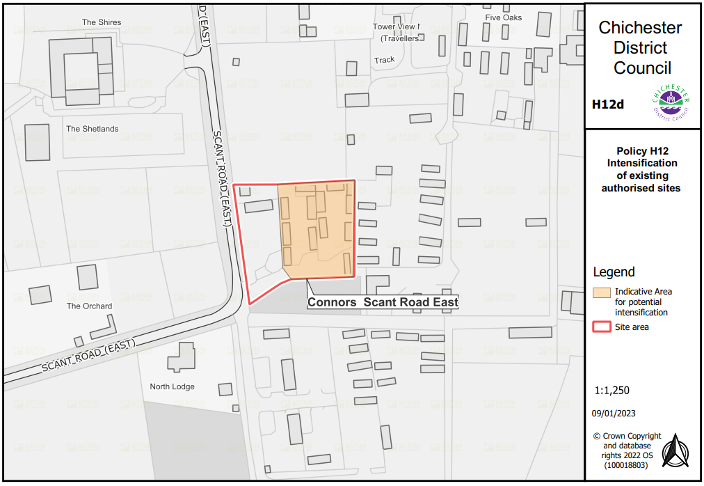
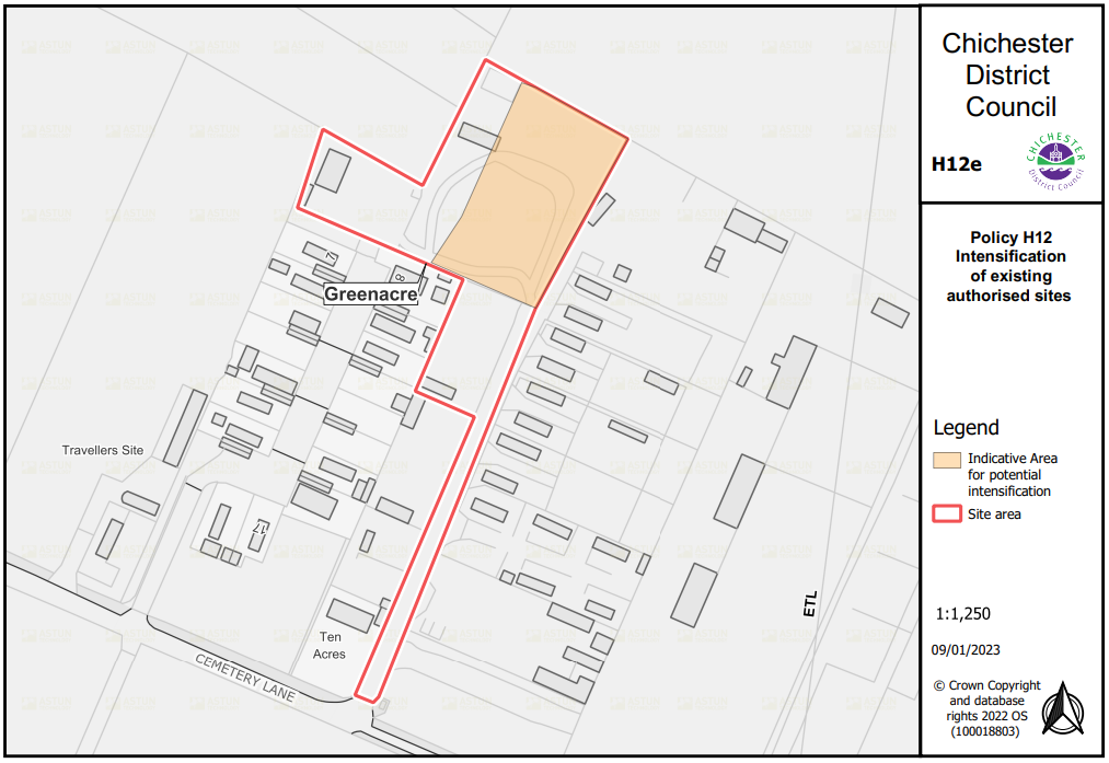
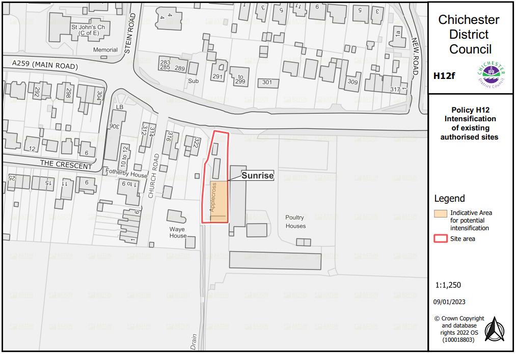
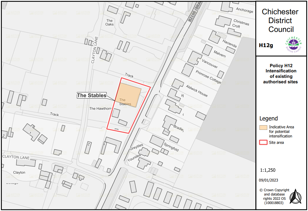
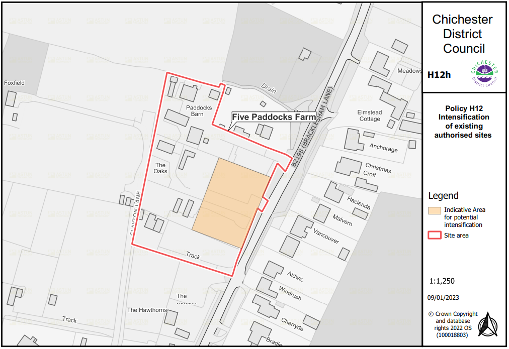
Appendix J: Gypsy and traveller site intensification plans (Policy H12)
Appendix K: Glossary
Active travel: Active travel means a mode of transport which involves physical activity such as walking and cycling to get from one destination to another, including travel to and from the places we live, work, learn, visit and play.
Affordable Housing: Housing for sale or rent, for those whose needs are not met by the market (including housing that provides a subsidised route to home ownership and/or is for essential local workers). For planning purposes, specific definitions of what constitutes affordable housing are set by Government and can change from time to time. The current definition is contained in the Glossary to the National Planning Policy Framework - https://www.gov.uk/government/publications/national-planning-policy-framework--2 and has set definitions under affordable housing for rent, starter homes, discounted market sales housing and other affordable routes to home ownership.
Air Quality Management Areas: These are declared in areas where national objectives for air quality are not being met, or at risk of not being met. They are declared by a local authorities who must then prepare an Action Plan to identify measures to meet the national air quality objectives.
Amenity: Positive elements that contribute to the overall character or enjoyment of an area. For example, open land, trees, historic buildings and the inter-relationship between them, or less tangible factors such as tranquillity.
Amenity space: External amenity space comprising for example: public and private gardens, roof terraces and balconies.
Ancient or veteran tree: A tree, which because of its age, size and condition, is of exceptional biodiversity, cultural or heritage value
Ancient woodland: An area that has been wooded continuously since at least 1600 AD.
Appropriate Assessment: An assessment of the potential effects of a proposed plan on one or more European Special Areas of Conservation. The 'assessment' proper is a statement which says whether the plan does or does not; affect the integrity of a European site.
Authority's Monitoring Report (AMR): This enables the local authority to assess the extent that the policies and proposals set out in the Local Plan are being achieved. The AMR allows the local planning authority to identify when a review of policies or proposals will be necessary.
Archaeological Priority Area: an area where there is significant known archaeological interest or potential for new discoveries. Used to help highlight where development might affect heritage assets.
Areas of Outstanding Natural Beauty (AONB): Areas of high scenic quality that have statutory protection in order to conserve and enhance the natural beauty of their landscapes. AONB landscapes range from rugged coastline to water meadows to gentle lowland and upland moors. Natural England has a statutory power to designate land as AONB under the Countryside and Rights of Way Act 2000. Chichester Harbour AONB is located within the Local Plan area. Also known as National Landscapes since a rebranding in 2022.
Article 4 Direction: A special planning regulation adopted by a local planning authority to provide additional powers of planning control in a particular location. It operates by removing "Permitted Development" rights over certain specified classes of minor alterations and extensions, such as porches, replacement of windows and doors and painting of the exterior of a building.
Biodiversity: The totality of genes, species, and ecosystems of a region.
Biodiversity net gain (BNG): is an approach to development, and/or land management, that aims to leave the natural environment in a measurably better state than it was beforehand
Biodiversity Opportunity Areas (BOAs): Biodiversity Opportunity Areas represent a targeted landscape scale approach to conserving biodiversity and the basis for an ecological network.
BREEAM New Construction: Is a standard against which the sustainability of new, non-residential buildings is assessed. Developers use the scheme at key stages to measure, evaluate, improve and reflect the performance of their buildings.
Coalescence: The merging or coming together of separate towns or villages to form a single entity.
Coastal squeeze: The loss of natural habitats, or deterioration of their quality, arising from human structures or actions, preventing the landward transgression of those habitats that would otherwise naturally occur in response to sea level rise together with other coastal processes. Coastal squeeze affects habitat on the seaward side of existing structures.
Community Infrastructure Levy (CIL): A levy allowing local authorities to raise funds from owners or developers of land undertaking new building projects in their area.
Community Facilities: Facilities that provide for the health and well-being, social, educational, spiritual, recreational, leisure and cultural needs of the community.
Comparison shopping: The purchase of items where the shopper compares the price and quality before a purchase is made, e.g. clothes, gift merchandise, electrical goods, and furniture. Generally high street shopping.
Compensatory habitat: Habitat created to offset loss or damage to Special Areas of Conservation, Special Protection Areas and Marine Conservation Zones, to maintain the coherence of natural networks.
Conservation Area: An area of special architectural or historic interest, designated under the Planning (Listed Buildings & Conservation Areas) Act 1990. There is a statutory duty to preserve or enhance the character, appearance, or setting of these areas.
Conservation Area Character Appraisal: An appraisal of the characteristics and features that are important to the character of a particular Conservation Area.
Convenience shopping: Broadly defined as food shopping, drinks, tobacco, newspapers, magazines and confectionery, purchased regularly for relatively immediate consumption. Generally supermarket shopping.
Density (Housing): The number of dwellings per net residential area, normally measured by dwelling per hectare.
Designated Heritage Asset: A World Heritage Site, scheduled monument, listed building, protected wreck site, registered park and garden, registered battlefield or conservation area designated under the relevant legislation.
Developer Contributions: Financial and physical contributions necessary and directly related to the needs of a development for infrastructure and community facilities. They are usually secured by the use of a planning obligation.
Development: Defined within the Town and Country Planning Act 1990 (as amended) as "the carrying out of building, engineering, mining or other operation in, on, over or under land, or the making of any material change in the use of any building or other land." Most forms of development require planning permission.
Development Plan: This includes adopted Local Plans (including Minerals and Waste Local Plans), neighbourhood plans, and is defined in Section 38 of the Planning and Compulsory Purchase Act 2004.
Development Plan Document (DPD): Formal plans that set out policies for a particular geographical area. They are subject to public consultation and a Sustainability Appraisal. They must also be considered at independent examination and obtain council approval before they can be adopted.
Environment Agency: A national organisation set up with effect from April 1996, assuming the responsibilities for environmental matters previously held by the National Rivers Authority, Her Majesty's Inspectorate of Pollution, and the Waste Regulation Authorities.
Environmental Impact Assessment (EIA): A procedure to be followed for certain types of project to ensure that decisions are made in full knowledge of any likely significant effects on the environment.
Extant: Current or still existing. Extant permissions include applications where planning permission has been granted and has not expired, the permission has a technical start or is under construction.
Flood Risk Assessment (FRA): An assessment of the likelihood of flooding in a particular area so that development needs and mitigation measures can be carefully considered.
Greenfield: An undeveloped site, especially one being evaluated and considered for commercial development.
Green and Blue Infrastructure: A network of multifunctional green and blue spaces and other natural features, urban and rural, which is capable of delivering a wide range of environmental, economic, health and well-being benefits for nature, climate, local and wider communities and prosperity. Green infrastructure includes trees, woodlands, orchards, parks, green walls/roofs and blue elements include rivers, canals, ponds, wetlands and floodplains
Gypsies and Travellers: Persons of nomadic habit of life whatever their race or origin, including such persons who on grounds only of their own or their family's or dependants' educational or health needs or old age have ceased to travel temporarily or permanently, and all other persons with a cultural tradition of nomadism or of living in a caravan, but excluding members of an organised group of travelling showpeople or circus people travelling together as such.
Habitats Regulation Assessment (HRA): The European Habitats Directive (92/43/EC) requires Appropriate Assessment of plans and projects that are either alone, or in combination with other plans and projects, likely to have a significant impact on national and international designated sites.
Health Impact Assessment (HIA): A health impact assessment considers the potential impacts of planning policies and decisions on health and health inequalities. They identify actions that can enhance the positive effects, and mitigation, or eliminate, the negative effects of development.
Heritage Asset: A building, monument, site, place, area or landscape identified as having a degree of significance meriting consideration in planning decisions, because of its heritage interest. Heritage asset includes designated heritage assets and assets identified by the local planning authority (including local listing).
Historic Environment Record (HER): an index to the known archaeological sites and finds, historic buildings, designed and historic landscapes, parks and gardens and scheduled monuments.
Historic parks and gardens: A park or garden of special historic value and have been included on the national Register of Parks and Gardens of special interest in England based on an assessment by Historic England.
Horticultural Development Areas (HDA): Locally designated areas for horticulture, the purpose of which is to promote this important sector of agriculture while protecting the environment and amenities of residents.
Infrastructure: The basic physical and organisational structures and facilities (e.g. buildings, roads, and power supplies) necessary for development to take place.
Infrastructure Delivery Plan (IDP): This will set out the current planned and required infrastructure, when it will come forward, who will be leading on each aspect and funding responsibilities.
International, European and locally designated sites of importance for biodiversity: All international sites (Special Areas of Conservation, Special Protection Areas, and Ramsar sites), national sites (Sites of Special Scientific Interest) and locally designated sites including Local Wildlife Sites.
Landscape Character Assessment: A background study that identifies the features or combinations of elements that contribute to the character of the landscape. LCA's can make a contribution to planning policies and the allocation of land for development.
Landscape Gaps: Areas of predominantly undeveloped land between settlements that protect the individual identity of those settlements and prevent their coalescence (the merging together of separate settlements to form one single settlement).
Listed Building: A building of special architectural or historic interest designated by Historic England and included on a statutory list. They are graded I, II* or II, with grade I being the highest.
Local Development Order: An Order made by a local planning authority (under the Town and Country Planning Act 1990) that grants planning permission for a specific development proposal or classes of development.
Local Enterprise Partnership (LEP): A body, designated by the Secretary of State for Communities and Local Government, established for the purpose of creating or improving the conditions for economic growth in an area. Government funding for LEPs ceased in 2024 with core functions being transferred to councils (primarily to West Sussex County Council in this area).
Local Nature Reserve (LNR): Designated under the National Parks and Access to the Countryside Act 1949 by Local Authorities in consultation with Natural England for their locally important wildlife or geological features.
Local Transport Plan: A five-year plan, which is drawn up by the Transport Authority in association with local authorities and subject to widespread consultation. It includes future investment plans and proposed packages of measures to meet local transport needs.
Local Wildlife Sites (LWS): A non-statutory designation made by West Sussex County Council. Their special characteristics mean they are high priority sites and their maintenance is important.
M4(2) Accessible and Adaptable Dwellings: Optional building standard met where a new dwelling makes reasonable provision for most people to access the dwelling and incorporates features that make it potentially suitable for a wide range of occupants, including older people, those with reduced mobility and some wheelchair users.
M4(3) Wheelchair Accessible Dwellings: Optional building standard met where a new dwelling makes reasonable provision, either at the point of completion or at a point following completion, for a wheelchair user to live in the dwelling and use any associated private outdoor space, parking and communal facilities that may be provided for the use of the occupants.
Main Town Centre Uses: Defined in the NPPF as retail development (including warehouse clubs and factory outlet centres); leisure, entertainment and more intensive sport and recreation uses (including cinemas, restaurants, drive-through restaurants, bars and pubs, nightclubs, casinos, health and fitness centres, indoor bowling centres and bingo halls); offices; and arts, culture and tourism development (including theatres, museums, galleries and concert halls, hotels and conference facilities)
Major Development: Major development is defined in legislation. In the Local Plan major development is considered to be any development which involves 10 or more dwellings (or a site of 0.5 hectares or more where the dwelling number is unknown) or the provision of a building or buildings with a gross internal floor area of 1,000 square meters or greater or the development on a site of 1 hectare or above.
Marine Conservation Zone (MCZ): Area designated to protect nationally important, rare or threatened marine habitats and species.
Masterplan: A document outlining the use of land and the overall approach to the design and layout of a development scheme in order to provide detailed guidance for subsequent planning applications.
Mitigation measures: Measures requested/carried out in order to limit the damage by a particular development or activity.
Mixed use (or mixed development): Provision of a mix of complementary uses, such as residential, community and leisure uses, on a site or within a particular area.
National Landscapes: Areas legally designated as areas of outstanding natural beauty under the National Parks and Access to the Countryside Act 1949 and Countryside and Rights of Way Act 2000.
National Nature Reserve (NNR): Designated under the National Parks and Access to the Countryside Act 1949 or the Wildlife and Countryside Act 1981 primarily for nature conservation but can also include sites with special geological or physical features.
National Park: Nationally important precious landscapes whose distinctive character and natural beauty are so outstanding that it is in the nation's interest to safeguard them. Together with Areas of Outstanding Natural Beauty they enjoy the highest level of protection through the planning system.
The Environment Act 1995 set out two statutory purposes for National Parks in England and Wales:
1. Conserve and enhance the natural beauty, wildlife and cultural heritage
2. Promote opportunities for the understanding and enjoyment of the special qualities of National Parks by the Public
National Parks have the duty to seek to foster the economic and social well-being of local communities. Within Chichester District, the South Downs National Park Authority (SDNPA) is the organisation responsible for promoting the purposes of the National Park and the interests of the people who live and work within it. The South Downs National Park lies outside of the plan area and is the subject of a separate Local Plan.
National Planning Policy Framework (NPPF): Sets out the Government's planning policies for England and how these are expected to be applied.
National Planning Practice Guidance (PPG): revised and updated planning practice guidance.
Nature Recovery Network (NRN): a single, national network which will benefit people and wildlife by increasing, improving and joining-up wildlife rich places across England. At its core will be enhanced sites designated for nature conservation and other existing wildlife rich places. Additional, newly created or restored nature rich habitat, corridors and stepping-stones will help wildlife populations grow and move. It will improve landscape resilience to climate change, provide natural solutions that reduce carbon and manage flood risk, and sustain vital ecosystems such as improved soil, clean water and clean air. It will reinforce the natural and cultural diversity of landscapes, help to protect historic environments, and enable people to enjoy and connect with nature where they live, work and play – benefiting health and well-being.
Neighbourhood Development Order: An Order made by a local planning authority (under the Town and Country Planning Act 1990) through which parish councils and neighbourhood forums can grant permission for a specific development proposal or classes of development.
Neighbourhood plans: A plan prepared by a parish council or Neighbourhood Forum for a particular neighbourhood area (made under the Planning and Compulsory Purchase Act 2004).
Noise sensitive properties/ receptors: these include all residential properties, educational establishments, hospitals, hotels, hostels, concert halls and theatres.
Non-designated heritage asset: buildings, structures and historic features which, while not statutorily protected by designation, are considered to be heritage assets of architectural, historic, archaeological or artistic interest. These heritage assets make a substantial contribution to the local character and appearance of the district and are worthy of conservation for the benefit of future generations.
Open Space: Open space includes formal facilities such as parks, sports and recreation grounds, children's play areas, outdoor sports facilities, playing pitches, amenity spaces and allotments, and also more informal facilities such as natural green spaces, beaches, lakes, watercourses and recreational routes.
Pitch/Plot: a pitch on a gypsy and traveller site and plot on a travelling showpeople site (often called a yard). This terminology differentiates between residential pitches for gypsies and travellers and mixed use plots for travelling showpeople, which may need to incorporate space to be split for the storage of equipment.
Planning obligation: A legally enforceable obligation entered into under S106 of the Town and Country Planning Act 1990 to mitigate the impacts of a development proposal.
Previously developed land (also known as brownfield land): Land which is or was occupied by a permanent structure, including the curtilage of the developed land and any associated fixed surface infrastructure. This excludes: land that is or has been occupied by agricultural or forestry buildings; land that has been developed for minerals extraction or waste disposal by landfill purposes where provision for restoration has been made through development control procedures; land in built-up areas such as private residential gardens, parks, recreation grounds and allotments; and land that was previously-developed but where the remains of the permanent structure or fixed surface structure have blended into the landscape in the process of time.
Primary and Secondary Shopping Frontages: Primary shopping frontages (PSF) are likely to include a high proportion of retail uses which may include food, drinks, clothing and household goods. Secondary shopping frontages (SSF) provide greater opportunities for a diversity of uses such as restaurants, cinemas and businesses.
Primary Shopping Area: An area where retailing and the number of shops in a town centre is most concentrated.
Priority habitats and species: Species and Habitats of Principal Importance included in the England Biodiversity List published by the Secretary of State under section 41 of the Natural Environment and Rural Communities Act 2006.
Protected species: plant and animal species afforded protection under certain Government Acts and Regulations
Ramsar sites: Wetlands of international importance, designated under the 1971 Ramsar Convention.
Renewable and low carbon energy: Renewable energy covers energy flows that occur naturally and repeatedly in the environment - from the wind, the fall of water, the movement of the oceans, from the sun and also from biomass and deep geothermal heat. Low carbon technologies help reduce emissions (compared to conventional use of fossil fuels).
Rural exception sites: Small sites used for affordable housing in perpetuity where sites would not normally be used for housing. Sites seek to address the needs of the local community by accommodating households who are either current residents or have an existing family or employment connection. Small numbers of market homes may be allowed at the local authority's discretion, for example where essential to enable the delivery of affordable units without grant funding.
S106: See planning obligations.
Scheduled Monument: A nationally important archaeological site included in the Schedule of Ancient Monuments maintained by the Secretary of State under the Ancient Monuments and Archaeological Areas Act 1979.
Self Build and Custom Build Housing: Self build homes are defined as those where someone directly organises the design and construction of their home. This covers a wide range of projects from a traditional DIY self-build home to projects where the self-builder employs someone to build their home for them. Community led projects can also be defined as self-build.
Custom build homes are where an individual or group works with a developer to help deliver the home(s). The developer may help to find a plot, mange the construction and arrange the finance for the new home(s).
Sensitive receptor: A sensitive receptor is a component of the natural or built environment such as a person, water, air, a building (e.g. residential, schools, hospitals/care home) or a plant, that is affected by an impact of construction works and/or the operation of a proposed development.
Sequential Test: A planning principle that seeks to identify, allocate or develop certain types or locations of land before others. For example, brownfield land before greenfield sites, town centres before out of centre and sites at less risk of flooding before others.
Sequentially preferable: a planning principle that seeks to identify, allocate or develop certain types or locations of land before others.
Settlement boundary: These are defined around settlements and their purpose is to prevent settlements from sprawling. Generally development proposals will be considered more favourably within the Built-Up Areas.
Site of Special Scientific Interest (SSSI): Sites designated by Natural England under the Wildlife and Countryside Act 1981.
Special Area of Conservation (SAC): Areas given special protection under the European Union's Habitats Directive, which is transposed into UK law by the Habitats and Conservation of Species Regulations 2010.
Special Protection Areas (SPA): Areas which have been identified as being of international importance for the breeding, feeding, wintering or the migration of rare and vulnerable species of birds found within European Union countries. They are European designated sites, classified under the Birds Directive.
Stepping-stones: Pockets of habitat that, while not necessarily connected, facilitate the movement of species across otherwise inhospitable landscapes.
Strategic Environmental Assessment (SEA): A procedure (set out in the Environmental Assessment of Plans and Programmes Regulations 2004) which requires the formal environmental assessment of certain plans and programmes which are likely to have significant effects on the environment.
Suitable Alternative Natural Greenspace (SANG): Alternative green space provided to divert visitors from visiting a Special Protection Area (SPA). SANG are intended to provide avoidance measures for the potential impact of residential development on the SPA by preventing an increase in visitor pressure on the SPA.
Supplementary Planning Documents (SPD): Documents which add further detail to the policies in the Local Plan. They can be used to provide further guidance for development on specific sites, or on particular issues, such as design. SPDs are capable of being a material consideration in planning decisions but are not part of the development plan.
Sustainability Appraisal (SA): A tool for appraising policies to ensure that they reflect sustainable development objectives (i.e. economic, social and environmental factors). It incorporates Strategic Environmental Assessment (SEA). An SA is required under the 2004 Planning and Compulsory Purchase Act to be carried out on all DPDs and certain SPDs.
Sustainable Drainage Systems (SuDS): systems designed to mimic the natural drainage of a site in order to control the quantity of run-off; and to enhance the nature conservation, landscape and amenity value of the site and its surroundings. These typically include swales, attenuation ponds, wetlands, and permeable surfaces.
Transit sites: Sites made available for Gypsies and Travellers who need to temporarily stop. Generally used by families who have been evicted from their previous accommodation and are looking for a new place to live. There are limits on how long families can stay on these sites which is normally between 28 days and 3 months.
Travelling Showpeople: Members of a group organised for the purposes of holding fairs, circuses or shows (whether or not travelling together as such). This includes such persons who on the grounds of their own or their family's or dependants' more localised pattern of trading, educational or health needs or old age have ceased to travel temporarily or permanently but excludes Gypsies and Travellers.
Use Classes Order (UCO): This is supplementary legislation which specifies a number of broad "classes of use"; changes of use can be made between different uses within the same class without the need for planning permission. In some circumstances it is possible to change between classes without applying for planning permission as specified by the General Permitted Development Order.
Wastewater Treatment Works (WwTW): also known as sewage treatment works where contaminants are removed from wastewater and sewage.
Water Framework Directive (WFD): This European Directive, together with emerging River Basin Management Plans, looks at integrated management of water resources, taking account of abstraction, water quality and flooding.
Windfall sites: Sites which have not been specifically identified as available in the Local Plan process. They normally comprise previously-developed sites that have unexpectedly become available.
Zone of Influence: The zone of influence is the area around an ecologically valuable site or habitat that may be affected by the proposed changes within the site. Impacts could include the removal or alteration of habitat, increased human presence on or around the site, or the introduction of artificial lighting within the site.